With the construction of the Grand Canal from the late 1750s, brought with it the expansion of Trade. goods could be carried from East to West along the line, this helped boost the development of the local economy from the late 18th century. The Offaly section of the canal runs approximately 42 miles and is home to a number of species and wild plants, due to the cross over through wet bog land during the development of the canal way[1].
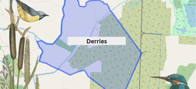
The first townland we come to along this way is Derries. It is situated in the Electoral Division of Ferbane, in the Civil Parish of Wheery or Killagally, in the Barony of Garrycastle, in the County of Offaly. The Irish name for Derries is Na Doirí meaning The Oak Woods.
Derries townland map. Image Source: Townlands.ie / Illustrations Nature on Irish Canals by Paul Francis
Wheery or Killagally is a large civil parish and it extends about 7 miles from Pollagh Village.
Pollagh also spelt as Pullough, is located in a small village in County Offaly, it is in the Civil Parish of Lemanaghan. A small parish, it extends from Ballycumber to Ferbane. Pollagh village can be found on the north side of the canal. The Parish lies in the territory of Dealbhna Eathra of the MacCoghlans – an ancient people. It has a rich heritage in its archaeology including the important monastic site, churches, and ringforts and the famous castles.
One of The townlands that we come along as we work our way down the line is Pollagh, the name in Irish is Pollach, meaning Place full of Holes.
Townland
Area
Pop in 1841
Pop in 1851
No. of Houses in 1841
No. of Houses in 1851
Pop in 1871
Pop in 1911
No. of Houses in 1871
No. of Houses in 1911
Pollagh
907
267
168
43
33
282
223
42
50
An interesting profile in the fall and rise of the population due one assumes to the successful brick industry.
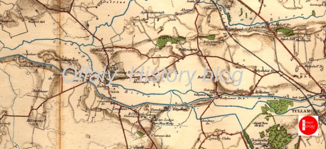
Rahan, Civil Parish is situated in the ancient O’Molloy territory of Fear Ceall meaning Men of the Woods or Men of the Churches. It is bounded on its north west side by the Brosna River. Its bedrock is Limestone and it has deposits of brick and clay along the Grand Canal.
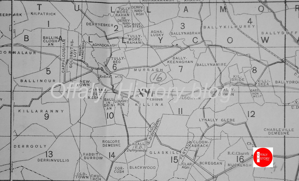
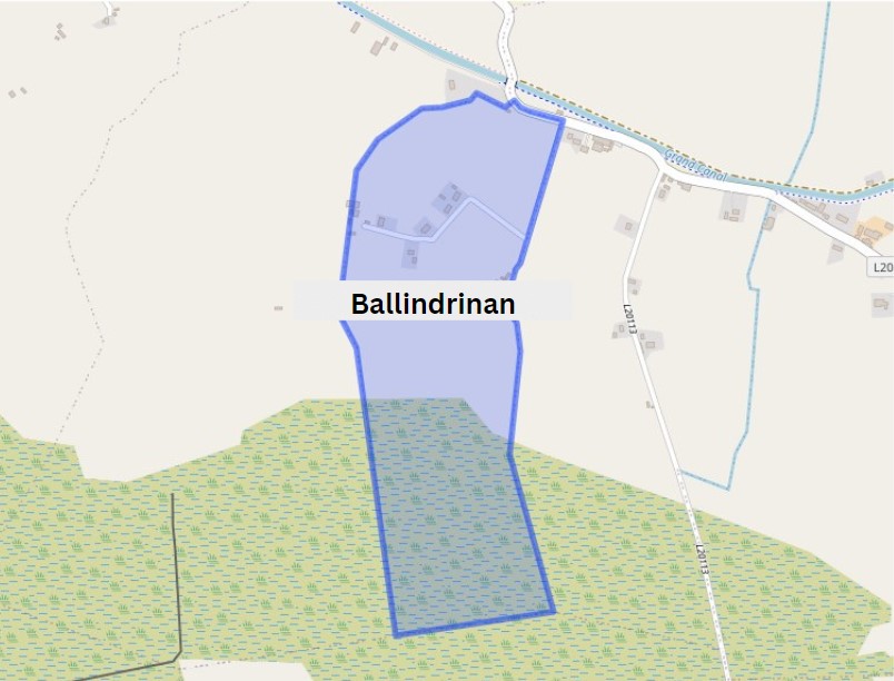
The townlands from Ballydrohid, Tullamore to CornalaurBallindrinan Townland/ Image Source Townlands.ie
Its best know archaeological site is the Rahan Monastic Centre which was an area of great importance in the early Christian Period.
Townland: Ballindrinan is in the Electoral Division of Rahan, in Civil Parish of Rahan, in the Barony of Ballycowan, in the County of Offaly.
The Irish name for Ballindrinan is Baile an Draighneáin meaning land of the blackthorns.
Kilgortin is in the Electoral Division of Rahan, in Civil Parish of Rahan, this parish is situated in the ancient O’Molloy territory of Fear Ceall meaning the mem of the woods or men of the churches. If you look closely along the line in this area you will see deposits of brick clays along the Grand Canal between Ballycowan and Rahan, this was the source of an energetic brick industry in the past. In this part of Rahan you will find the site of Rahan Monastic Centre, this is the most famous archaeological site in this location. It was a very important aspect of Early Christian period.
Frank Mitchell (1912–97) was a distinguished but unassuming academic, environmental historian, archaeologist and geologist. While he had many academic writings his best known book was The Irish Landscape (1976) about which he was typically modest. In 1990 Mitchell published ‘a semi-autobiography’ The way that I followed. The title was a play on Robert Lloyd Praeger’s, The way that I went (Dublin, 1937). A delightful exercise in ‘topographical autobiography’. Praeger in his peregrinations was less kind to Laois and Offaly than Mitchell with Praeger’s observation that ‘neither county need detain us long’ (p. 235) and ‘there is not much of special interest’ (p. 237). Westmeath he found to be more hospitable than Offaly having less than half of the amount of bog in Offaly and more pasture. We may look at the Praeger account in another blog. Suffice to say that bogs were not flavour of the month with the visitors from the 1800s to the 1930s and who wrote up accounts of their tours. Mitchell did not follow that century old prescription.
Someone who Mitchell would have known (at TCD) and admired was T.W. Freeman. The latter’s Ireland a general and regional geography (1950, third edition, 1963) provided a useful account of the boglands east of the Shannon and the eskers of the Central Lowland with a brief disquisition on the market towns ‘that differ so strangely in their material prosperity’. Freeman was fascinated by the unexpected and haphazard nature of economic life in some of the towns – he seems to have had in mind Tullamore and Clara.
In any case let us go back to look at what Mitchell wrote of the terrain east of the Shannon as part of this Grand Canal series.
Jane W. Shackleton’s Ireland compiled by Christiaan Corlett (Cork, 2012) is an attractive large format publication was issued by Collins Press and consists of 180 well produced photographs by Jane Shackleton. These pictures are important for the photographic record in County Offaly and mostly date to 1894.
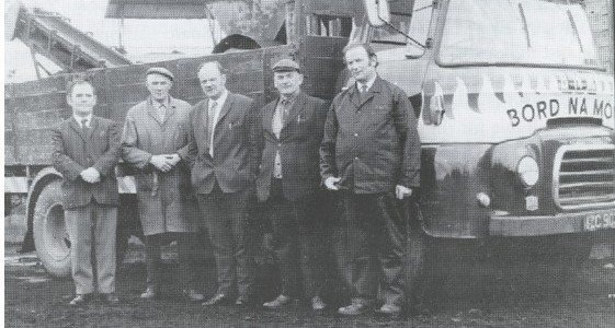
Not surprisingly there are many pictures of mills in this book and there are about ten pictures of Offaly interest. Jane Shackleton started taking pictures in the 1880s and made several tours on the Shannon and along the Grand Canal and Barrow lines. These waterways photographs contribute greatly to the history of the canals and the great mills which were associated with river locations. Many of these were in fact owned by Quaker industrialists. Like other interested women of the period Jane Shackleton was a member of the Royal Society of Antiquaries (RSAI) and took photographs of some of their tours including that of June 1904 around Ireland. Midleton Biddulph, the amateur photographer and retired army officer of Rathrobin near Tullamore was also on this trip and some of his pictures survive and have been published as Rathrobin and the two Irelands; the photographs of Middleton Westenra Biddulph, 1900–1920 (Tullamore, 2021). Corlett informs us that the Shackleton collection consists of 1,000 lantern slides and 44 albums containing several thousand prints, mostly of Irish subjects. This writer had the pleasure of seeing some of the Grand Canal and the turf works at Pollagh back in the early 1970s with Richard Shackleton and Jonathan Shackleton.
Down the Decades was launched in Rahan Hall in November 2023 with a large audience and since then the new book by Tom Minnock has proved to be extremely popular with more copies printed to meet the demand. We asked Tom Minnock to tell us in this blog article about how the book came about.Born in 1922, the life of George Griffith tracked the life of the new Irish State, down through the decades. George never left his native Clonshanny giving him a local perspective on community life in the area during a fascinating period in the history of Ireland and the world.George Griffith died in March 2022.
Tom’s book is a collection of George’s reflections on that century up to 2022. Tom has set the context both locally and globally for each decade.
Tom Minnock writes:
The book is out there now and it is a peculiar feeling that is hard to put into words as something that you have spent countless hours living with takes wings. A few random words sketched out on a large note book and transferred on to a computer screen had grown and grown over time. How did this come about and why do I think it was important to publish it and expose myself to my community to be judged? I would like to share the journey and in doing so challenge you all reading this to consider writing or sharing your stories with somebody who will set them down for a future generation to ponder and continue the process.
We need wind energy, but are we to give up on saving the bogs and destroying natural and community amenity in the process? This article looks at the works at Clongawney bog and the real threat to Lemanaghan and the natural heritage of County Offaly. More transparency is needed and more care about what outcomes we intend to have in Offaly in regards to our landscape. Will the area of Lemanaghan be now destroyed? We in Offaly need to revisit this and ensure care is taken and proposed works assessed by independent experts . The works proposed for Lemanaghan need to be scrapped or scaled back to protect what should be a special conservation area. Communities need to know what is happening to their local landscape. What has happened so far at Clongawney?
Clongawney works
It is difficult not to be disturbed and distressed by the images below which shows excavation in progress for a wind turbine base in Clongawney bog. There is an enormous amount of destruction and disruption for a relatively small base. And what makes the situation much worse and even more disturbing is that the turbine is clearly located in bog wetlands. In a few years this area will be covered in vegetation and will be home to a variety of wildlife. And right in the middle will stand a massive turbine with massive blades. The bogs are special places. They have suffered so much over the last 70 years. Ignorance and necessity may be the explanation for what happened. However there is no excuse now. This is permanent destruction of our bogs. How can this be allowed to happen ?
Below are photographs of the works at Clongawney Bog near Banagher and the works which must conflict will all our plans to protect the natural environment.
CLONGAWNEY IS LOST. DERRINLOUGH IS LOST. LEMANAGHAN IS NEXT.
There can be few places in Ireland of more historic importance than Lemanaghan. The image above shows the location of several toghers which have been found on Lemanaghan Bog. Amazingly the largest togher on Lemanaghan can be seen clearly from space! Click on the Google Earth link and be astonished.As can be clearly seen from the map above the bog is criss-crossed with ancient toghers and holds an array of archaeological sites. It would be unthinkable to put wind turbines on the callows or the eskers or the bogs that surround
Links in higher resolution to some of the pictures below.
This is a dramatic way to show this fabulous togher Lemanaghan Togher
The massive dumper which can be seen on this image helps size this extraordinary motorway type junction on Clongawny Bog. This motorway/roadway will only be used once to transport the components for a turbine and then….? To comprehend the scale of what is happening you need to visit to Clongawny.This find took place a few weeks ago on Clongawny Bog, just a mile or so from Banagher. Note wind turbine construction activity in the background. It is piece of timber with at least two square holes worked by human hand, possibly two thousand years ago. The piece is located on the side of a drain about half metre below the bog surface. No doubt there are many more precious archaeological artefacts and sites awaiting discovery in Clongawny and Lemanaghan and in other bogs.This image shows an extensive deposit of bog iron ore also on Clongawny Bog. In the background are tens of thousands of stone are being poured onto the bog surface.
Bord Na Mona Bogs in 2023 A Brief Summary
Peat harvesting ended in 2020 but finished on many bogs more than 20 years earlier. There is at least 1 metre of bog remaining on all bogs and more than 2 metres in most places.
Return to nature
A wide variety of vegetation has become established on many bogs with little interference from anyone with the possible exception of the blocking main drains. Drinagh is now a beautiful area of perhaps 1000 acres with wide expanses of vegetation interspersed with water and inhabited by a variety of wild life.
Rewetting
Extensive ‘rewetting’ has been carried out on a few bogs. This mainly involves the construction of ‘berms’ about 3/4 metres high and up to 7 metres wide thereby dividing the bog into fields a few acres in size. The berms prevent water runoff and hopefully in time will lead to growth of sphagnum moss. This system is totally dependent on rainfall and long dry spells will be a significant test as well as fire risk when berms dry out. Derrinboy bog is a good example and is easily accessed from the Kilcormac- Kinnitty road.
Wind turbines
Wind turbines were erected on Mount Lucas bog a few years ago and are now in progress on Clongawney and Derrinlough bogs. Because of the heavy and sizeable components a grid of motorway type roads have to be constructed on the bogs. These are supported on mats of very heavy duty plastic as bogs are not capable of taking weight. On completion access is secured and controlled by BNM. If Mount Lucas is taken as an example wind turbine farms will not be an attractive place to visit unless cycling or walking on 7 metre wide ‘straights’ can be considered exciting. There is a real fear that at some point in the not too distant future BNM wind farms will be packaged and sold off to international investor funds.
Tracks and Trails
Substantial state funding is now available to help make the 10s of 1000s of acres of post peat harvesting bogs interesting and attractive places to visit for locals and visitors. The management of this fund seems to rest entirely with BNM. There are hundreds of kilometres of bog rail track which can be easily made into walking and cycle ways. All of the bogs have raised headlands where no harvesting took place and these are ideal and save places for cycling or walking. It is important that those playing a role in the design of this project have a familiarity with and sensitivity to the bogs and to the locality.
Please see an invitation from the community in Lemanaghan about two events this Saturday 12 August as part of Heritage Week. We are publishing early this week as part of our Heritage Week Specials from 12 to 20 August. So keep in touch with us on Social Media and do call to Offaly History Centre and Offaly Archives as part of next week’s 2023 programme.
The community of Lemanagahan extend a special invitation to you for a truly remarkable event – the book launch of “The Annals of Clonmacnoise” where the links with Lemanaghan will be discussed by the author Nollaig Ó Muraíle. Event Details: Date: Saturday, August 12th, 2023 Time: 2:30 PM Venue: The Granary, Boher, Ballycumber, Offaly, N35NX30 [beside St. Manchans Church]
“The Annals of Clonmacnoise” is a meticulously compiled chronicle that offers a panoramic view of Ireland’s past. Through its pages, you’ll be transported to a world of ancient tales, historical intrigue, and cultural treasures that have shaped the very essence of our heritage.
My story starts as a small boy growing up in Dillon Street, Tullamore in the 1940s. I remember seeing a cutting from a newspaper which I presumed was from a Tipperary weekly paper. The article covered a report of a feis and sports held in a field at the Golden Vale Hotel in Dundrum Co. Tipperary. It mentioned about the Misses Crummy from Ballydine taking part in the Irish dancing. A small report on the opposite side of the cutting was headed
Shooting near Birr. Charged at Birr with conspiring in 1923 to kill and killing John Finlay, Tullamore. Chas and Peter Molloy and Michael Coyne were sent for trial.
What is so unusual about this paper cutting from 1923?
My mother, one of the Misses Crummy mentioned in the article, was now working in Tullamore for T. English & Co. She met and married my father Thomas, brother of John Finlay some ten years later.