The sisters of Saint Joseph of Cluny first arrived in Ferbane on the 12th of May 1896. Their arrival and the arrival of those who followed in their footsteps were to have a significant impact on the community of Ferbane and to the education of young women in the midlands of Ireland.
The order of Saint Joseph of Cluny was founded in France in 1807 by Blessed Anne-Marie Javouhey. Having grown up in the aftermath of the French Revolution, her dictum was “to love the children” and make a great effort to improve their education to as high a degree as possible”.
“We have been asked to go to Ireland, to teach the poor and the well to do. I have been assured that we could do much good there. If such be the will of God, I agree to this foundation with all my heart”.[1]
Blessed Anne Marie wrote the above in 1850. However, it was ten years before four sisters, led by Mother Callixte Pichet, arrived in Dublin, and set up residence in a former Carmelite monastery in Blanchardstown. The congregation grew and within a year, twenty-three Irish girls had joined the order. The community continued to expand and in 1864 the sisters established their first secondary school for girls at Mount Sackville, situated in the idyllic location above the valley of the river Liffey adjoining Dublin’s Phoenix Park.
Mount Sackville would take its place among the leading secondary schools in Ireland and continues to be synonymous with the education of young women 160 years later.
We need wind energy, but are we to give up on saving the bogs and destroying natural and community amenity in the process? This article looks at the works at Clongawney bog and the real threat to Lemanaghan and the natural heritage of County Offaly. More transparency is needed and more care about what outcomes we intend to have in Offaly in regards to our landscape. Will the area of Lemanaghan be now destroyed? We in Offaly need to revisit this and ensure care is taken and proposed works assessed by independent experts . The works proposed for Lemanaghan need to be scrapped or scaled back to protect what should be a special conservation area. Communities need to know what is happening to their local landscape. What has happened so far at Clongawney?
Clongawney works
It is difficult not to be disturbed and distressed by the images below which shows excavation in progress for a wind turbine base in Clongawney bog. There is an enormous amount of destruction and disruption for a relatively small base. And what makes the situation much worse and even more disturbing is that the turbine is clearly located in bog wetlands. In a few years this area will be covered in vegetation and will be home to a variety of wildlife. And right in the middle will stand a massive turbine with massive blades. The bogs are special places. They have suffered so much over the last 70 years. Ignorance and necessity may be the explanation for what happened. However there is no excuse now. This is permanent destruction of our bogs. How can this be allowed to happen ?
Below are photographs of the works at Clongawney Bog near Banagher and the works which must conflict will all our plans to protect the natural environment.
CLONGAWNEY IS LOST. DERRINLOUGH IS LOST. LEMANAGHAN IS NEXT.
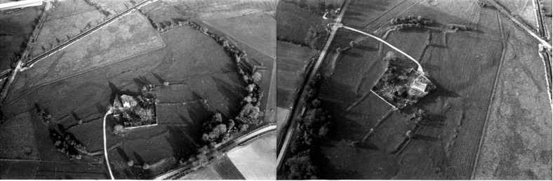
There can be few places in Ireland of more historic importance than Lemanaghan. The image above shows the location of several toghers which have been found on Lemanaghan Bog. Amazingly the largest togher on Lemanaghan can be seen clearly from space! Click on the Google Earth link and be astonished.As can be clearly seen from the map above the bog is criss-crossed with ancient toghers and holds an array of archaeological sites. It would be unthinkable to put wind turbines on the callows or the eskers or the bogs that surround
Links in higher resolution to some of the pictures below.
This is a dramatic way to show this fabulous togher Lemanaghan Togher
The massive dumper which can be seen on this image helps size this extraordinary motorway type junction on Clongawny Bog. This motorway/roadway will only be used once to transport the components for a turbine and then….? To comprehend the scale of what is happening you need to visit to Clongawny.This find took place a few weeks ago on Clongawny Bog, just a mile or so from Banagher. Note wind turbine construction activity in the background. It is piece of timber with at least two square holes worked by human hand, possibly two thousand years ago. The piece is located on the side of a drain about half metre below the bog surface. No doubt there are many more precious archaeological artefacts and sites awaiting discovery in Clongawny and Lemanaghan and in other bogs.This image shows an extensive deposit of bog iron ore also on Clongawny Bog. In the background are tens of thousands of stone are being poured onto the bog surface.
Bord Na Mona Bogs in 2023 A Brief Summary
Peat harvesting ended in 2020 but finished on many bogs more than 20 years earlier. There is at least 1 metre of bog remaining on all bogs and more than 2 metres in most places.
Return to nature
A wide variety of vegetation has become established on many bogs with little interference from anyone with the possible exception of the blocking main drains. Drinagh is now a beautiful area of perhaps 1000 acres with wide expanses of vegetation interspersed with water and inhabited by a variety of wild life.
Rewetting
Extensive ‘rewetting’ has been carried out on a few bogs. This mainly involves the construction of ‘berms’ about 3/4 metres high and up to 7 metres wide thereby dividing the bog into fields a few acres in size. The berms prevent water runoff and hopefully in time will lead to growth of sphagnum moss. This system is totally dependent on rainfall and long dry spells will be a significant test as well as fire risk when berms dry out. Derrinboy bog is a good example and is easily accessed from the Kilcormac- Kinnitty road.
Wind turbines
Wind turbines were erected on Mount Lucas bog a few years ago and are now in progress on Clongawney and Derrinlough bogs. Because of the heavy and sizeable components a grid of motorway type roads have to be constructed on the bogs. These are supported on mats of very heavy duty plastic as bogs are not capable of taking weight. On completion access is secured and controlled by BNM. If Mount Lucas is taken as an example wind turbine farms will not be an attractive place to visit unless cycling or walking on 7 metre wide ‘straights’ can be considered exciting. There is a real fear that at some point in the not too distant future BNM wind farms will be packaged and sold off to international investor funds.
Tracks and Trails
Substantial state funding is now available to help make the 10s of 1000s of acres of post peat harvesting bogs interesting and attractive places to visit for locals and visitors. The management of this fund seems to rest entirely with BNM. There are hundreds of kilometres of bog rail track which can be easily made into walking and cycle ways. All of the bogs have raised headlands where no harvesting took place and these are ideal and save places for cycling or walking. It is important that those playing a role in the design of this project have a familiarity with and sensitivity to the bogs and to the locality.
Early in the summer of the year 697, probably in May, a great assembly of kings, bishops and abbots, along with their followers and servants, took place in Birr. It was a joint meeting of kings (rígdál) and of church leaders (synod). They came together to proclaim a law for the protection of women, children, clerics and other people who did not bear arms, in times of conflict. The law was called Cáin Adomnáin or the ‘Law of the Innocents’ (Lex Innocentium) and later referred to in a poem as the ‘Great Law of Bir
Mag Léna is of interest for two events that occurred in the early historic period. The first event is the pseudo historic Battle of Mag Léna. The second event was the significant Synod of Mag Léna and the Letter of Cummain, part of the Irish church row with Rome over the dating of Easter.
Both incidents caused a split in Ireland!
What’s in a name?
Mag Léna is mentioned in logainm.ie as Moylena and places it in the parish of Kilbride, Co. Offaly. Mag or Magh translates as a plain or open country, there is no information provided on the meaning of the word Léna. Unusually, there are no additional references other than the basic location details, also this older relic from the original card index system below. A 13th century manuscript mentions Cath Mhuighe Léana. Magh Léana is mentioned elsewhere. In his Survey Letters we find O’Donovan used a variety of spellings for the name – Moylena, Moyléna, Moyleana, Moleany and Moy-leana.
Logainm index card for Mag Léna.
As usual there are difficulties with the older Gaelic placenames and how they were recorded over time. Today the only memory of the name is in Tullamore, where the Moylena road joins the Clara Road and eventually joins the Rahan Road through Glendaniel.
Contributed by Offaly History to mark the occasion
The new book, St Manchan’s Shrine, by Griffin Murray and Kevin O’Dwyer was launched to great acclaim by the CEO of the Heritage Council Virginia Teehan on Friday 21 October 2022 at Offaly History Centre, Tullamore before a large and distinguished audience. Proceedings began at 5 30 p.m. with Amanda Pedlow ably acting as chair and introducing the four speakers. First was the author of the text Griffin Murray, followed by silversmith and photographer Kevin O’Dwyer. The County Offaly CE Anna Marie Delaney skillfully chartered the progress being made in regard to the county’s heritage while CEO Virginia Teehan paid tribute to the county for its wide-ranging involvement in heritage projects and availing of the funding available. The new Offaly Archives was a leading case but one among many successful projects undertaken. Another is that of the funding received to create the post of a biodiversity officer. Offaly has demonstrated its ability to secure funding for projects and that was a reflection of the work being done in the county. Ms Teehan congratulated the authors, Griffin Murray and Kevin O’Dwyer, on a job well done. Yet another exemplar.
The earliest writing is recorded in eastern Asia about 5,000 years ago. The spread was westwards with the use of earthen (cuneiform) tablets that are still found today in the Tells of modern Iraq and in the Fertile Valley. Cuneiform tablets were mainly used for recording stock control items and account balances; at the same time Egyptian hieroglyphs were starting to record the stories of the Pharaohs.
Cuneiform and Hieroglyphs
The Greeks and Romans introduced writing to the Mediterranean countries and it spread across Europe to Britain with the arrival of the first Roman invasion in 55BC.
Ogham is the first recorded writing in Ireland, based on inscriptions on stone. Ogham is a language based on the Roman alphabet. The influence of the Roman empire had introduced the Latin language and writing to most of Europe. Only two other societies used stone – Pictish symbols in Scotland and Norse Runes in northern Europe. Ogham stones are found in Ireland and in the Irish areas of influence in Scotland and Wales.
Archaeologically speaking there are many different types of enclosure in Ireland, many dating from some thousands of years ago and built for many different reasons. Some of the different types include:
Henge. A large, enclosed, prehistoric, circular or oval area usually over 70m in diameter which is defined by an earthen bank and a (usually internal) shallow but broad ditch. They can contain a variety of internal features including timber or stone circles. They are ceremonial/ritual monuments and date to the Late Neolithic/Early Bronze Age (c. 2800-1700 BC). They have between 2 – 4 entrances. There are no henges in Offaly.
Just 18 henges survive in Ireland today, one of the largest is at Ballynahatty (7 acres) just SW of Belfast and which contains a small passage tomb containing the remains of a unique Neolithic woman. The most well-known henge is probably that at Dowth at Brú na Bóinne.
Ballynahatty and Dowth Henges
Barrow. A circular or oval raised area (generally over 1m above the external ground level) with an external ditch and sometimes an outer bank. They contain burials and were in use from the Bronze Age to the Iron Age (c. 2400 BC – AD 400). There are at least seven different types of barrow in Ireland.
There are 41 barrows in Offaly, at least 30 ring-barrows and 5 bowl barrows.
Durrow Abbey with two ring-barrows side by side (yellow dots), OS map
Coolcreen in the Sliabh Blooms with 5 barrows adjacent to one another, OS map
Ring Ditch. A bedrock cut ditch or trench of circular or penannular plan, usually identified through aerial photography either as soil marks or cropmarks. When excavated, ring ditches are usually found to be the ploughed‐out remains of a round barrow where the barrow mound has completely disappeared, leaving only the infilled former ditch.
There are 6 ring ditches in Offaly none of which are visible at ground level. Sometimes, they only appear as crop marks on the ground.
Two ring-ditches (yellow dots), Lehinch near Clara, OS map
Ringfort or rath. A roughly circular or oval area surrounded by an earthen bank with an external ditch. Some examples have two (bivallate) or three (trivallate) banks and fosses, but these are less common and have been equated with higher status sites belonging to the upper grades of society. They functioned as residences and/or farmsteads and broadly date from 500 to 1000 AD. Ringforts have seen the most destruction in recent times, primarily to release the enclosed space for agriculture even though protected by law as National Monuments. Ringforts made from stone are called cashels.
There are 199 ringforts in Co. Offaly, mainly clustered in the south of the county.
Three ringforts, Broughal, Co Offaly, OS map
Hillfort. A large enclosed area that is usually encompassing between 2 and 22 hectares (diam. exceeding c. 160m). Hillforts are always located in high upland terrain and are very prominent locally. They are defined by an earthen bank/banks or a wall/walls and can be circular, oval or more irregularly shaped if following the contours of a hilltop. In the case of bivallate or multivallate examples, the banks are often widely spaced. They may have been important ceremonial or tribal centres and/or permanent or temporary settlements. Some examples date from the Early Neolithic (c. 3600 BC), others from the Middle to Late Bronze Age (c. 1400-500 BC) with examples of reoccupation in the later Iron Age (c. 100-400 AD).
There are two hillforts in Offaly, one at Ballymacmurragh NE of Longfort village, it is made of two banks and is almost surrounded by forestry. The second is close by at Aghancon and is made up of two widely separated banks and is one of the largest on the island covering 14 acres.
Ballymacmurragh and Aghancon Hillforts, OS map
How to find enclosures.
There are many techniques used to identify enclosures.
Where archaeological remains are suspected but where no evidence is visible at ground level the use of ground level geophysics can reveal detailed layouts of buildings, sites, roadways, enclosures, etc.
Aerial photography allows us to compare sites over many years, commencing in the middle of the last century particularly with the work of Leo Swan and Norman & St Joseph of Cambridge University. Pioneer JK St. Joseph qualified as a geologist and then lectured in Cambridge University. During WWII he analysed photographs taken by RAF photographers. Using his wartime experience he understood the potential of aerial photography to analyse archaeological sites. One of his earliest publications was Monastic Sites from the Air published in 1952.
Aerial photography has also identified enclosures through cropmarks where nothing is visible at ground level. Cropmarks generally appear when crop growth is aligned with dry conditions.
Leo Swan was the first to exclusively examine Irish ecclesiastical sites from the air starting in 1971. He combined his aerial research with study of the six-inch OS maps. In addition, he had access to the documentary evidence from the Early Medieval period. He identified 400 ecclesiastical sites through photography and added another 200 sites through his field work.
Someone with time on their hands can go and compare the early OS maps with these early aerial photos and today’s satellite photos and identify the destruction of the very large number of archaeological sites in their own locality.
One of the other major contributions that Leo Swan made to the archaeological investigations of early church sites from his aerial and field work was to produce a list of features which are consistently found on these sites and lists them in order of frequency:
Evidence of enclosure
Burial area
Place name with ecclesiastical element
Structure, or structural remains such as church or Round Tower
Holy well
Bullaun stone
Carved, shaped, inscribed, or decorated stone cross or slab
Line of townland boundary forming part of the enclosure
Souterrain
Pillar stone
Founder’s tomb
Associated traditional ritual or folk custom
Radiating road network
Triangular market area, commonly but not always on the east
Swan suggests that there will be four or five of these features that survive in most cases.
For hundreds of years the enclosures remained untouched whether through folklore – the Púca, Fairy Fort or an area of liminality, the bridge between the living and the dead. It was the arrival of the tractor pulling the plough that rubbed these ancient sites off the landscape.
ECCLESIASTICAL ENCLOSURES
What do we mean by early Irish churches? The early churches were made of wood, no archaeological trace of these wooden churches have survived. They were simple, rectangular shaped with one door and one window (perhaps) facing east to west, with the door pointing to the west. Stone churches arrived around 500 – 800AD with almost the same layout as the wooden churches. Church architecture remained the same until the arrival of the Continental monks and the reforms of the Irish church in the 1100s. Only a handful of early ecclesiastical sites have been fully excavated, 41 have had partial/limited excavations carried out.
How many ecclesiastical enclosures are there in Co. Offaly? The National Monuments database has a list of 22 ecclesiastical enclosures in Offaly while Elizabeth FitzPatrick in her 1998 paper ‘The Early Church in Offaly’ lists 6 enclosure sites with a possible 5 others. Mervyn Archdall (1723 – 1791) lists 32 ancient Offaly churches in his Monasticon Hibernicum, many of the names he gives can no longer be located today. Later FitzPatrick and O’Brien list eight very large enclosures in their 1998 book on the Medieval Churches of County Offaly.
Swan suggests that there are at least 2,000 early church sites in Ireland. The Stout husband and wife team suggest that there were over 5,500 pre-Norman ecclesiastical sites in Ireland. In addition, it is suggested that over 6,000 townlands contained the name Cill in their placename.
What is an Ecclesiastical enclosure? A large oval or roughly circular area, usually over 50m in diameter, defined by a bank/banks and external fosse/ditch or drystone wall/walls, enclosing an early medieval church or monastery, its graveyard and its associated areas of domestic, agriculture or industrial activity. These date to the early medieval period (5th-12th centuries AD). Sometimes hedges, field fences and field boundaries have replaced the original enclosures.
The Early Irish Church developed independently from the European Roman model which was based on the cities of the Roman Empire, connected by the great European road systems. These European cities had a church centre led by a bishop. The Irish system developed independently to the degree that major reform was demanded by the European and English Church in the 12th century.
These early church establishments are not to be confused with the later and very different medieval abbeys and friaries of the Continental orders that arrived in the 1100s.
A circular pattern for the layout of early Irish church sites was adopted from an early date. There may not have been a written down plan but there was a general pattern almost universally accepted to which the early sites seem to have conformed. These church sites were surrounded by banks of earth constructed in a way used for constructing ring forts, so the skills for construction were readily available. Many church sites had two banks with a very small number having three banks. It appears to have been a universal pattern. The enclosure contained the church, burial ground, other church structures such as round tower and high cross.
Only a small number of Offaly churches retain enclosures visible in the landscape today. However, as discussed earlier there are many techniques available for identifying where enclosures may have been robbed away. Many are very similar in size to ring forts while some of the largest sites are comparable with the largest hillfort.
Many problems exist with a mere surface examination of these enclosures, the most important of which is their dating. Without excavation it is nearly impossible to give a date to the construction of an enclosure. In addition, many of these enclosures display later mediaeval occupation and farming traces at surface level.
Where there was insufficient earth to make an enclosure a number of church sites, particularly on islands in the west of Ireland designed their enclosures and built them in stone. Examples include Skellig, Ilauntannig and Inismurray. These church sites survive today particularly as pilgrimage sites.
Holy of Holies and Sanctuary.
Two features of the Christian church that appear early are the concept of the Holy of Holies and the concept of Sanctuary. Both would have been strange to the Irish people used to the Druidic rituals usually held in groves/woods. Conversion to the new church and its rituals was slow and took hundreds of years to complete, many of the older Celtic rituals survive to modern times – reverence to the holy well, the rag tree and the perpetual fire.
The Holy of Holies is a term from the Hebrew Bible and relates to the inner sanctuary of the Tabernacle where God’s presence appeared in Israel. The area held the Ark of the Covenant which contained the ten Commandments, given by God to Moses on Mount Sinai.
The concept of Sanctuary stretches back to the Cities of Refuge of the six Levitical towns in Israel and Judea in which the perpetrators of accidental manslaughter could claim the right of asylum. Mention of refuge and sanctuary can be traced back to the Old Testament and the Books of Deuteronomy, Exodus, Joshua and Numbers.
Charles Doherty (UCD) has suggested that the Irish had a concept of sanctuary based on the biblical ‘city of refuge’ whereby the monastic site is considered a holy of holies at the core, around which are areas of sanctuary that decrease in importance the further you move away from the centre. Doherty describes the first area of sanctuary as Sanctissimus, the second Sanctior and the third as Sanctus.
With the growth of Irish ecclesiastical settlements, it became increasingly important to protect the sanctity of the holy area, prevent the violation of graves, control the influx of pilgrims and protect the wealth of the church. In addition, it was necessary to protect those fleeing and seeking sanctuary and preventing raids from other churches and princes. In Europe the concept of sanctuary was intimately linked to the right of asylum from the 5th century. A Roman law, passed in 419AD set the sanctuary boundary to a circuit of 50 paces around the place of worship. It is not clear when the concept of sanctuary expired.
Were these enclosures defensive? If so, they were a miserable failure. We know the accounts of how easily the Vikings raided the monasteries. Less well known are the accounts of raids by the Irish on the monasteries. The Annals are littered with such raids. One monastery in Offaly is recorded many times. Clonmacnoise did not appear to like its neighbours – Birr, Durrow or Kinnitty.
U760.8 A battle between the communities of Cluain Mac Nois and Biror in Móin Choise Blae.
U764.6 The battle of Argaman between the community of Cluain Moccu Nóis and the community of Dermag (Durrow), in which fell Diarmait Dub son of Domnall, and Diglach son of Dub Lis, and two hundred men of the community of Dermag. Bresal, son of Murchad, emerged victor, with the community of Cluain. Both quotes from the Annals of Ulster.
And in 842 Kinnitty and Clonmacnoise were at war. So much for the Isle of Saints and Scholars!
Durrow also suffered: burned in 1095, 1153 and twice in 1155. In 1175 Durrow was devastated by Hugh de Lacy of Meath.
The Annals of the Four Masters describe other destruction in Offaly.
M800.10 Cill Achaidh (Killeigh) was burned, with its new oratory.
M952.11 Saighir Chiarain was plundered by the men of Munster.
M1548.9 Saighir and Kilcormac were burned and destroyed by the English and O’Carroll
There are many other cases where sanctuary was ignored by the local Irish lords such as described in the Annals
AI1180.3 Ard Ferta Brénainn (Ardfert) was plundered by the Clann Charthaig, and they carried off all the livestock they found therein. They put many good people to death inside its sanctuary and graveyard; but, indeed, God avenged that, for a large number of those plunderers were forthwith slain.’
Another mention in the Annals of Ulster recount an Irish raid on Donaghpatrick, Co Meath
U746.11 Violation of sanctuary at Domnach Pátraic, six captives being hanged.
An attempt to halt the slaughter of monks and laity and re-establish the sanctity of sanctuary was attempted by Adomnán at the Synod of Birr in 697 AD. Adomnán, then abbot of Iona, collected an assembly of religious and royal leaders headed by Loingsech mac Oengusso then Cencl Connaill, King of Tara. The synod passed Cáin Adomnáin also known as the Law of the Innocents. The law provided sanctions against those who killed children, clerics or farm labourers within a church sanctuary, however it failed in its implementation.
THE ENCLOSURES IN OFFALY
Durrow
Durrow, the Columban site was the location of the murder of Hugh de Lacy in his attempts to build a fort and establish his claims to the lands of Mide (Meath). Whether his plan was to build a Motte and Bailey or a stone fort such as that at Trim is unknown. However, the earlier Irish enclosure can still be seen as cropmarks in the field to the south and east of the church.
The outer enclosure has a double bank with a ditch/fosse in between, perhaps, 500m in diameter. Did the inner enclosure represent the area of sanctuary?
The Life of Colmcille tells us that Colmcille requested Cormac O Liathain that the abbot ‘set in order the monastery and enclose it well’. Elsewhere, it mentioned that 150 workers erected an enclosure that ‘there might not be a breach therein’ and that the oak trees of Dar Magh were cut down to provide stakes for protection of all sides of the monastery.
The following drawing was made by Sterling de Courcy Williams in 1899. The remains of the enclosure can be seen south of the church and swinging west in the direction of the motte.
A story in the Life of Colmán of Lynally recounts that a raiding party from Durrow stole earth from Lynally’s enclosure that Colmán had brought back from Rome. Did they put it into their own enclosure?
Sterling de Courcy Williams drawing of the Termon of Durrow, 1899 & Leo Swan photos1
Clonmacnoise.
There is no trace of the first great monastery of St Kieran. This was one of the most important early schools, founded at the edge of the River Shannon in 544.
Seirkieran/Saighir.
Like Birr, Seirkieran sat on the old provincial border between Mumu (Munster) and Mide (Meath) and suffered from regular tensions particularly with the southern Ui Neill. Impressive substantial earthen banks, separated by a ditch/fosse still surround the church at Seirkieran, enclosing an area of about 12 ha.
Geoffrey Keating has an account of the building of an enclosure at Seirkieran, ‘at this time Sadhbh, Queen of Ireland, wife of the Ard Righ Donnchadh, son of Flann Sionna and daughter of Donnchadh King of Ossory grieved that Saighir the burial place of her ancestors lay open and defenceless while so many other famous churches in Ireland were encircled by walls induced her royal husband to send a number of masons from Meath to erect a suitable wall of stone around the cemetery’. This account implies a stone wall around the Seirkieran graveyard; however, archaeology has failed to find this wall. It confirms other accounts that Seirkieran was the burial place of the Kings of Ossory at this time; Keating states that ‘the burying place of the kings of Osruighe was at Saighir Chiaráin’.
Photos of Seirkieran by Leo Swan2
Rahan.
This site contains the church of St Carthage in its original enclosure with the original earthen ramparts around it. The monastery is inside a large D shaped enclosure with the River Clodiagh forming the northern boundary. The enclosure is 500 m x 325 m, covering field boundaries to the south, west and east. The outer bank is made from earth with an external bank/fosse. In 1870 Thomas Stanley described the inner enclosure as having two earthen banks with intervening fosse.
In recent times Dr Paul Gibson has carried out extensive geophysical surveys of the interior which reveals sub-rectangular inner enclosures.
Rahan from early and current OS maps
Killeigh.
The enclosures around Killeigh are probably the largest in the country. Many elements of them have survived, the remainder ploughed out. The full extent of the enclosures is best seen through aerial photography and survives in the south east of the village. Another part can be seen to the south west of the village in a field to the west of a lane that runs past Abbey Farm. Otherwise, elements of the original enclosures are seen as ragged cropmarks from aerial photography.
Artistic view of Killeigh Historic Landscape published on Offaly.ie
Cooleeshill.
Close to Roscrea this enclosure is an impressive cashel, built of stone on the basis that stone was more readily available than earth. This site is dedicated to St. Kieran of Seirkieran.
Cooleeshil from OS maps
Wheery
Another early site with a river as a significant element of the enclosure, similar to Durrow and Seirkieran. Earlier called Kilwheery. Situated on the flood plains of the river Brosna the river provides the southern boundary of a D-shaped enclosure measuring 55m x 35m at maximum. From an account in the Kilkenny Archaeological Journal, during drainage works in 1849 a bell, enclosed in a shrine was found in a pool in the Brosna just beside the site.
Maps from the early OS surveys and modern satellite photo
Kildangan – Tihilly
Tihilly is located between Tullamore and Durrow. Human bones are said to have been found in the site which was levelled during the last century and is no longer visible at ground level. The ecclesiastical enclosure consisted of a large circular area enclosed by an earthen bank which acted as a circular field boundary. The site seems to have contained a graveyard and a holy bush. Folklore stories collected in the 1930s describe the annual Patron Day rituals carried out at Tihilly. The comparison between the 1830s OS map and the modern photo identifies the destruction to the original church site for agricultural purposes.
Maps from the early OS surveys and modern satellite photo
Fancroft.
Early church enclosure within an archaeological rich landscape containing church and graveyard. There is no modern access road but there is a trace of a sunken road to the NE of the site that may have led to the original church site.
Recently nominated by the Irish Times as amongst the twenty best places to live in Ireland, Tullamore earned the accolade because of its central location and its excellent recreational amenities and services. However, neither its built or natural environment figured as deciding factors in the survey.
Regrettably, my home town lacks the physical drama of Kilkenny and Lismore dominated by fortresses standing on cliffs, the waterside charms of Kinsale and Carrick on Shannon, the mystery of the mediaeval alleyways of Galway and Carlingford or the suave urban quality of Westport, Clonakilty and Birr. Nevertheless, it’s qualities, modest as they are, have always inspired me and I have often tried to capture them in drawings. Tullamore’s few architectural setpieces were my first introduction to the notion that a town or a village could be a beautiful artefact as much as a painting or a piece of sculpture.
We are pleased to welcome a new contributor and old friend Dr Mary Jane Fox. She has contributed to Offaly Heritage journal.
Saint Colmcille[1] is very much a part of Offaly’s history, almost exclusively due to the early monastic site of Durrow. It is not certain exactly when he founded Durrow, but the land for it was possibly gifted to him either by Aedh, a son of Bréanainn, king of southern Uí Néill kingdom of south Tethbae,[2] or Ainmuire mac Sétnai, a prince from the Cenél Conaill branch of the northern Uí Néill. In both cases it was likely to have taken place around 553.[3
There has been significant controversy over the years regarding St. Colmcille’s copying a psalter belonging to his teacher, St. Finnian of Moville. Doubt about the event itself and events subsequent to it still persist, and the mystery has never truly been solved. For something that occurred almost 1500 years ago, how would that be possible anyway? Granted, it might never be solved, but we might find ourselves a few steps closer to what happened if we reconsider what sort of evidence we are seeking and what we consider acceptable.
‘A rich and dazzling Celtic bewilderment, a perpetual challenge to the eyes and a perpetual delight.’ T.D. Kendrick (Archaeologia 86, 1936)
Saint Manchan’s shrine is one of the most remarkable survivals from Ireland’s medieval past, having been safely kept and venerated in the same locality since its creation in the early twelfth century. This masterpiece of medieval art is now proudly and reverently displayed in the rural parish church of Boher in County Offaly, not far from its original home at the ancient church site of Lemanaghan. St Manchan’s shrine is a gabled-reliquary, taking the shape of steeply pitched roof or tent, and is fitted with carrying rings, which enabled it to be carried in procession by two bearers using poles. It is not only the largest reliquary surviving from medieval Ireland but is also the only remaining example of its type. It enshrines what are believed to be the bones of its eponymous saint, St Manchan, whose death is recorded in AD 664.