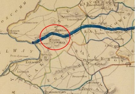
Kilgortin is in the Electoral Division of Rahan, in Civil Parish of Rahan, this parish is situated in the ancient O’Molloy territory of Fear Ceall meaning the mem of the woods or men of the churches. If you look closely along the line in this area you will see deposits of brick clays along the Grand Canal between Ballycowan and Rahan, this was the source of an energetic brick industry in the past. In this part of Rahan you will find the site of Rahan Monastic Centre, this is the most famous archaeological site in this location. It was a very important aspect of Early Christian period.
This article looks at the north Offaly towns featured in Major (later general) Vallancey’s report carried out in 1771 and designed to support the construction of the new Grand Canal line to Tullamore and the Shannon. Vallancey was then a young engineer, employed to report to the Commissioners of Inland Navigation and his findings were published in, AReport on the Grand Canal or Southern Line (Dublin 1771).[1] This report is useful as a window on some of the north King’s County (hereafter generally referred to as Offaly) towns and villages.[2]
A singlehanded trip from the River Shannon to the town of Tullamore along the western section of the Grand Canal was conducted by the writer over seven days in August, 2023. The trip was conducted aboard the heritage vessel Bomb Scow a converted thirty-three foot Royal Navy seaplane tender. Our thanks to Donal Boland for this comprehensive overview of the Brosna Line, Shannon Harbour to Tullamore which is better presented as one extensive with its helpful picture coverage. This comprises articles 6 to 10 in the series on Grand Canal Offaly.
Content
Overview
Entrance from the River Shannon
First Lock Number 36
Lock 36 to 35
Lock 35 to 34 Shannon harbour
Lock 34 to 33 Clonony Barracks
Lock 33 Belmont…
Belmont to Tullamore
Memories
Appendix 1: Hull and Spoke Concept
Appendix 2: The Napoleonic Aspect
1. Overview
A singlehanded trip from the River Shannon to the town of Tullamore along the western section of the Grand Canal was conducted by the writer over seven days in August, 2023. The trip was conducted aboard the heritage vessel Bomb Scow a converted thirty-three foot Royal Navy seaplane tender.
The trip, was a fact-finding event to record the on-water experience as part of an initiative to highlight the possibility of attracting more visitors to this section of the canal. Described here as The Grand Extension, previous research had revealed its construction was later than the eastern section of the canal and forming part of the British Militaries Napoleonic defensive network.
The route commenced in the west on the callow fringed landscape of the River Shannon, travelling through boglands on a raised section of the canal and terminating to the east in an Esker dominated upland landscape, encountering the villages of Shannon Harbour, Belmont, Ferbane, Pollagh, Rahan and the town of Tullamore.
The Stllwater Navigation extending for a distance of twenty two miles and rising some ninty feet is comprised historically of the waterway, ten locks, twenty bridges, eighteen aquaducts, four feeders and four spillways. Presently the waterway is managed by four lock keepers or waterway patrollers with overlapping areas of responsibility, who operate the lock systems and control the sections water levels.
The Grand Extension, Town and Villages The heritage vessel Bomb Scow moored on The Grand Extension
2. Entrance from the River Shannon
The Stillwater navigation of The Grand Extension is accessed from the River Shannon by way of the Brosna River and its confluence with the Shannon. This entrance is characterised by magnificent over-hanging foliage to the north and earthen banks associated with the canal’s construction to the south. An isolated, derelict bridge-keeper’s cottage that stands on Bullock Island is passed as you enter the River Brosna waterway.
The confluence of the River Brosna waterway with the River Shannon
The River Brosna waterway
The confluence of the River Brosna Waterway and The Grand Extension
3. Lock Number 36
Lock 36 is the final, lowest lock on the Grand Canal system and the first lock you meet when arriving from the River Shannon. A long, floating jetty stands on the southern bank immediately below the lock, providing access to land by way of a large sloping ramp. The lock constructed of cut-stone is entered via wooden balanced, hanging gates that incorporate water control sluices, operated by the lock keeper utilising a rack and pinion mechanism mounted on the gates topside. The gates are opened and closed by way of the long balance beam that extends from each gate.
An engraved stone plaque mounted on the north wall of the lock, details the construction and features of the extension.
The entrance to Lock 36 and its large waiting jetty
The empty cut-stone lock chamber and wooden gates
The full lock chamber and upper-gates
The upper lock gates opened and the ever-attendant lock keeper
4. Lock 36 to 35
This short section of the canal provides an initial experience and understanding of the Stillwater navigation. It is many times narrower than the River Shannon with a defined navigation path bordered by moored vessels to the north and a rich reed-based ecosystem to the south.
Entering the first section of The Grand Extension
The short canal section extending from Lock 36 to Lock 35
Lock 35
5. Lock 35 to 34
The second, Lock 35 on the system, provides access from the first level up to the second level which is comprised of Shannon Harbour, Griffith and Clonony bridges and a section of canal extending to the thirty fourth lock that contains numerous moored vessels for most of its length The waterway beyond the moored vessels starts to provide an understanding of the true characteristics of this Stillwater navigation.
A feature of this canal is the construction of bridges and locks immediately adjacent to one another, this allowed for the transfer of horses (which were originally employed to pull barges along the navigation) from one towpath to the other.
Entering Shannon Harbour
Shannon Harbour
The canal extending to Clonony Bridge and Lock 34
Clonony Bridge and Lock 34
6. Lock 34 to 33
The section of canal east of Lock 34 is best described as the military section as along its northern bank lies the remains of Clonony Military Barracks – most likely the military destination of the canal and the reason it was constructed swiftly. The military grounds are defined to the west by a wooden fence and metal gate and to the east by a long roadside timber fence. The towpath within the military grounds is substantially wider encompassing a lay-by or mooring area. Immediately east of the military grounds lies L’Estrange Bridge and Quay which was utilised by the L’Estrange family for commercial purposes possibly associated with the barracks.
The canal beyond L’Estrange Bridge and Quay displays its mature natural character as a tranquil linear still-waterway navigation mostly devoid of habitation and humanity broken only by the arrival of Belmont Mill.
The Eastern and Western boundaries of the Military Lands
The lay-by and broader towpath within the Military Grounds
L’Estrange Bridge / Quay and Belmont Store
The magnificent natural features of The Grand Extension
7. Lock 33
Lock 33 or Belmont Lock is the only double lock on the Grand Extension. A double lock is constructed when a high lift is required at a location. The standard lift for locks on the canal is circa eight feet while the lift a Belmont Lock is some fifteen feet. Transiting this lock is a delightful experience hard to describe and best experienced.
Belmont Mill and Lock
Lock 33 at Belmont
Filling the lower level
Filling and emerging from the upper level 8.Belmont to Tullamore
The canal extending east from Belmont Lock to Tullamore is best described as isolated continuous delightful for some and a horror for others. The mind may transition into a relaxed static state imbibing the natural landscape and the activities of inhabiting creatures or one may be bored to insanity. The architecture of the locks, bridges and associated buildings coupled with the relatively unchanged landscape propels one back in time to the period of the canal’s construction in the early eighteen hundreds. This relaxation is interspersed by interludes of surprise and delight when a bridge is encountered and frantic activity when locking from one level to another. The villages of Gallen/Ferbane, Pollagh and Rahan when encountered are a connection with present times providing basic mooring facilities. The town of Tullamore provides an opportunity for the replenishment of supplies and the possibility of fresh water. The facilities available to the canal traveller are sparse and presently reflect the industrial era of canal usage.
A simple water tap
The continuous Stillwater Navigation
A canal bridge endowed with generations of growth
Bell’s Bridge and Lock 32
Gallen Village, bridge and rest area
Gallen Village bankside mooring area
Pollagh Village and Canal-Side facilities
Lock 31
Lock 30 and the canal manager’s house.
The canal-side facilities at Rahan Village and the Thatch pub – a former Williams branch shop
Ballycowan Castle of 1626 and beside it the Huband aqueduct dated to 1803. Huband was a barrister and a director of the Canal Company from 1777 for most of the years to 1835.
Srah Castle, Bridge and and the railway bridge
Sragh Bridge and Lock 28
Entering Tullamore at the Clara Road Lock 29
The spur from the canal main line to Tullamore Harbour
The canal side facilities in Tullamore Town
9. Memories
Memories of this trip are especially positive
The waterway was weed free with a good water level
The courtesy and efficiency of the water patrollers was first class
The lock landings were in a good condition
The lock operating systems all worked well
The lock surrounds were neat and well maintained
The lock keeper’s cottages were a joy to behold
Canal-side moorings and services were adequate and of their time
Growing up on Clontarf Road, Tullamore, on the banks of the Grand Canal in the 1950s and 1960s I spent many childhood hours playing beside the canal. This was where my father’s family had lived for generations in East View Terrace before he and several of his siblings had acquired houses in Frank Gibney’s new state-of-the-art housing on Clontarf Road. In early teenage years I took to walking the canal line and ventured to Kilgortin Mill and Rahan, where my mother’s people, my grandfather and uncles and a multiplicity of cousins, lived. Not surprisingly the canal got under my skin if not indeed into my bloodstream.
Hiking west from Tullamore the ‘canal line’ took us to exotic locations: The Metal Railway Bridge and slow-moving trains, the inaccessible Srah Castle, Molloy’s Bridge for in-season snowdrops and horse chestnuts and the hugely impressive six-chimneyed Ballycowan Castle, overlooking the imperious and impervious Huband Aqueduct. Rambling east towards Cappancur we soon explored in detail the small aqueduct which seemingly miraculously ushered the Barony River under the canal and were further allured by the rotundity of Boland’s lockhouse and a lock manned by a team of sisters. Graduating to the bicycle we set out along the towpath for far-flung towns and villages: Ballycommon and the Wood-of-O, the Kilbeggan Branch, historic Daingean and the outré but warm and welcoming church at Pollagh.
Grand canal from the 27th lock at Cox’s Bridge, Tullamore about 1910Continue reading →
Brother Pat Guidera S.J. (born 1900, died 1992) was a familiar figure in Tullamore over a period of forty-two years from his transfer to Tullabeg College in 1948 up to its closure in 1990. Today the old college is falling to ruin. Many will recall its very good order up to the 1990s and thereafter it was used in part as a nursing home. Brother Guidera wrote a short ‘Story of my life’ in 1991 and this is an extract from that now very scarce memoir – of which there is a copy in Offaly Archives (courtesy of the Irish Jesuit Archives). The college was opened in 1818 and several volumes have been published on its history but few as intimate as that of Bro. Guidera. His memoir is interesting also for the marked distinctions in the religious orders between those fully ordained and those who were effectively providing support services in the college or convent. Brother Guidera was a carpenter cum painter and many will remember him carrying the usual large carton of cigarettes in the town for his colleagues in the college. His recollections of life in the Rahan area show the value of personal histories so why not give it a go.
Township could be said to have begun in Tullamore in 1622. On 30 September the anniversary will be marked with an outdoor exhibition of drawings by Fergal MacCabe and a Timeline of Events showing the story of the town since the earliest times. We have covered many stories of Tullamore in over 420 blogs published in this series. All can be accessed on www.offalyhistory.com. For a quick link to all these resources see @offalyhistory
My grandmother was Margaret Lambe from Greatwood, Killoughy. Her sister married Thomas Lawless of the pub at the Blue Ball. Margaret married Timothy Conroy of Cloonagh. My mother Bridget(1904-87 , was her eldest child. She was the eldest of nine sisters and one brother, the youngest of the family who died in his infancy, and she was reared by her grandmother in Greatwood from a very young age. Margaret, my grandmother, died in 1916 after childbirth from postpartum bleeding. My mother was sent as a boarder to the convent in Ferbane run by “The French nuns” as they were known [The French missionary order of the Sisters of St Joseph of Cluny who came to Ferbane in 1896.] In my mother’s time some of the nuns in residence were born in France and still spoke French to each other. The records of her time there survive and she was an outstanding student. In November 1918, Stanislaus Murphy, Secretary to the Commissioners of Education in Ireland wrote to her, “Miss Bridget M. Conroy, The French Nuns Convent, Ferbane”, informing her that she had won, what was known as, the Banagher prize. The money paid her fees for that year in the school in Ferbane. The full title of the prize was the Diocesan Schools and Banagher Royal School Endowments.[1] My mother was very proud of her Banagher prize and she retained the letter from the Department as a prized reminder. In her old age she did put the laconic comment; “She must have had brains once!” on the back of the letter telling her of the award.
Archaeologically speaking there are many different types of enclosure in Ireland, many dating from some thousands of years ago and built for many different reasons. Some of the different types include:
Henge. A large, enclosed, prehistoric, circular or oval area usually over 70m in diameter which is defined by an earthen bank and a (usually internal) shallow but broad ditch. They can contain a variety of internal features including timber or stone circles. They are ceremonial/ritual monuments and date to the Late Neolithic/Early Bronze Age (c. 2800-1700 BC). They have between 2 – 4 entrances. There are no henges in Offaly.
Just 18 henges survive in Ireland today, one of the largest is at Ballynahatty (7 acres) just SW of Belfast and which contains a small passage tomb containing the remains of a unique Neolithic woman. The most well-known henge is probably that at Dowth at Brú na Bóinne.
Ballynahatty and Dowth Henges
Barrow. A circular or oval raised area (generally over 1m above the external ground level) with an external ditch and sometimes an outer bank. They contain burials and were in use from the Bronze Age to the Iron Age (c. 2400 BC – AD 400). There are at least seven different types of barrow in Ireland.
There are 41 barrows in Offaly, at least 30 ring-barrows and 5 bowl barrows.
Durrow Abbey with two ring-barrows side by side (yellow dots), OS map
Coolcreen in the Sliabh Blooms with 5 barrows adjacent to one another, OS map
Ring Ditch. A bedrock cut ditch or trench of circular or penannular plan, usually identified through aerial photography either as soil marks or cropmarks. When excavated, ring ditches are usually found to be the ploughed‐out remains of a round barrow where the barrow mound has completely disappeared, leaving only the infilled former ditch.
There are 6 ring ditches in Offaly none of which are visible at ground level. Sometimes, they only appear as crop marks on the ground.
Two ring-ditches (yellow dots), Lehinch near Clara, OS map
Ringfort or rath. A roughly circular or oval area surrounded by an earthen bank with an external ditch. Some examples have two (bivallate) or three (trivallate) banks and fosses, but these are less common and have been equated with higher status sites belonging to the upper grades of society. They functioned as residences and/or farmsteads and broadly date from 500 to 1000 AD. Ringforts have seen the most destruction in recent times, primarily to release the enclosed space for agriculture even though protected by law as National Monuments. Ringforts made from stone are called cashels.
There are 199 ringforts in Co. Offaly, mainly clustered in the south of the county.
Three ringforts, Broughal, Co Offaly, OS map
Hillfort. A large enclosed area that is usually encompassing between 2 and 22 hectares (diam. exceeding c. 160m). Hillforts are always located in high upland terrain and are very prominent locally. They are defined by an earthen bank/banks or a wall/walls and can be circular, oval or more irregularly shaped if following the contours of a hilltop. In the case of bivallate or multivallate examples, the banks are often widely spaced. They may have been important ceremonial or tribal centres and/or permanent or temporary settlements. Some examples date from the Early Neolithic (c. 3600 BC), others from the Middle to Late Bronze Age (c. 1400-500 BC) with examples of reoccupation in the later Iron Age (c. 100-400 AD).
There are two hillforts in Offaly, one at Ballymacmurragh NE of Longfort village, it is made of two banks and is almost surrounded by forestry. The second is close by at Aghancon and is made up of two widely separated banks and is one of the largest on the island covering 14 acres.
Ballymacmurragh and Aghancon Hillforts, OS map
How to find enclosures.
There are many techniques used to identify enclosures.
Where archaeological remains are suspected but where no evidence is visible at ground level the use of ground level geophysics can reveal detailed layouts of buildings, sites, roadways, enclosures, etc.
Aerial photography allows us to compare sites over many years, commencing in the middle of the last century particularly with the work of Leo Swan and Norman & St Joseph of Cambridge University. Pioneer JK St. Joseph qualified as a geologist and then lectured in Cambridge University. During WWII he analysed photographs taken by RAF photographers. Using his wartime experience he understood the potential of aerial photography to analyse archaeological sites. One of his earliest publications was Monastic Sites from the Air published in 1952.
Aerial photography has also identified enclosures through cropmarks where nothing is visible at ground level. Cropmarks generally appear when crop growth is aligned with dry conditions.
Leo Swan was the first to exclusively examine Irish ecclesiastical sites from the air starting in 1971. He combined his aerial research with study of the six-inch OS maps. In addition, he had access to the documentary evidence from the Early Medieval period. He identified 400 ecclesiastical sites through photography and added another 200 sites through his field work.
Someone with time on their hands can go and compare the early OS maps with these early aerial photos and today’s satellite photos and identify the destruction of the very large number of archaeological sites in their own locality.
One of the other major contributions that Leo Swan made to the archaeological investigations of early church sites from his aerial and field work was to produce a list of features which are consistently found on these sites and lists them in order of frequency:
Evidence of enclosure
Burial area
Place name with ecclesiastical element
Structure, or structural remains such as church or Round Tower
Holy well
Bullaun stone
Carved, shaped, inscribed, or decorated stone cross or slab
Line of townland boundary forming part of the enclosure
Souterrain
Pillar stone
Founder’s tomb
Associated traditional ritual or folk custom
Radiating road network
Triangular market area, commonly but not always on the east
Swan suggests that there will be four or five of these features that survive in most cases.
For hundreds of years the enclosures remained untouched whether through folklore – the Púca, Fairy Fort or an area of liminality, the bridge between the living and the dead. It was the arrival of the tractor pulling the plough that rubbed these ancient sites off the landscape.
ECCLESIASTICAL ENCLOSURES
What do we mean by early Irish churches? The early churches were made of wood, no archaeological trace of these wooden churches have survived. They were simple, rectangular shaped with one door and one window (perhaps) facing east to west, with the door pointing to the west. Stone churches arrived around 500 – 800AD with almost the same layout as the wooden churches. Church architecture remained the same until the arrival of the Continental monks and the reforms of the Irish church in the 1100s. Only a handful of early ecclesiastical sites have been fully excavated, 41 have had partial/limited excavations carried out.
How many ecclesiastical enclosures are there in Co. Offaly? The National Monuments database has a list of 22 ecclesiastical enclosures in Offaly while Elizabeth FitzPatrick in her 1998 paper ‘The Early Church in Offaly’ lists 6 enclosure sites with a possible 5 others. Mervyn Archdall (1723 – 1791) lists 32 ancient Offaly churches in his Monasticon Hibernicum, many of the names he gives can no longer be located today. Later FitzPatrick and O’Brien list eight very large enclosures in their 1998 book on the Medieval Churches of County Offaly.
Swan suggests that there are at least 2,000 early church sites in Ireland. The Stout husband and wife team suggest that there were over 5,500 pre-Norman ecclesiastical sites in Ireland. In addition, it is suggested that over 6,000 townlands contained the name Cill in their placename.
What is an Ecclesiastical enclosure? A large oval or roughly circular area, usually over 50m in diameter, defined by a bank/banks and external fosse/ditch or drystone wall/walls, enclosing an early medieval church or monastery, its graveyard and its associated areas of domestic, agriculture or industrial activity. These date to the early medieval period (5th-12th centuries AD). Sometimes hedges, field fences and field boundaries have replaced the original enclosures.
The Early Irish Church developed independently from the European Roman model which was based on the cities of the Roman Empire, connected by the great European road systems. These European cities had a church centre led by a bishop. The Irish system developed independently to the degree that major reform was demanded by the European and English Church in the 12th century.
These early church establishments are not to be confused with the later and very different medieval abbeys and friaries of the Continental orders that arrived in the 1100s.
A circular pattern for the layout of early Irish church sites was adopted from an early date. There may not have been a written down plan but there was a general pattern almost universally accepted to which the early sites seem to have conformed. These church sites were surrounded by banks of earth constructed in a way used for constructing ring forts, so the skills for construction were readily available. Many church sites had two banks with a very small number having three banks. It appears to have been a universal pattern. The enclosure contained the church, burial ground, other church structures such as round tower and high cross.
Only a small number of Offaly churches retain enclosures visible in the landscape today. However, as discussed earlier there are many techniques available for identifying where enclosures may have been robbed away. Many are very similar in size to ring forts while some of the largest sites are comparable with the largest hillfort.
Many problems exist with a mere surface examination of these enclosures, the most important of which is their dating. Without excavation it is nearly impossible to give a date to the construction of an enclosure. In addition, many of these enclosures display later mediaeval occupation and farming traces at surface level.
Where there was insufficient earth to make an enclosure a number of church sites, particularly on islands in the west of Ireland designed their enclosures and built them in stone. Examples include Skellig, Ilauntannig and Inismurray. These church sites survive today particularly as pilgrimage sites.
Holy of Holies and Sanctuary.
Two features of the Christian church that appear early are the concept of the Holy of Holies and the concept of Sanctuary. Both would have been strange to the Irish people used to the Druidic rituals usually held in groves/woods. Conversion to the new church and its rituals was slow and took hundreds of years to complete, many of the older Celtic rituals survive to modern times – reverence to the holy well, the rag tree and the perpetual fire.
The Holy of Holies is a term from the Hebrew Bible and relates to the inner sanctuary of the Tabernacle where God’s presence appeared in Israel. The area held the Ark of the Covenant which contained the ten Commandments, given by God to Moses on Mount Sinai.
The concept of Sanctuary stretches back to the Cities of Refuge of the six Levitical towns in Israel and Judea in which the perpetrators of accidental manslaughter could claim the right of asylum. Mention of refuge and sanctuary can be traced back to the Old Testament and the Books of Deuteronomy, Exodus, Joshua and Numbers.
Charles Doherty (UCD) has suggested that the Irish had a concept of sanctuary based on the biblical ‘city of refuge’ whereby the monastic site is considered a holy of holies at the core, around which are areas of sanctuary that decrease in importance the further you move away from the centre. Doherty describes the first area of sanctuary as Sanctissimus, the second Sanctior and the third as Sanctus.
With the growth of Irish ecclesiastical settlements, it became increasingly important to protect the sanctity of the holy area, prevent the violation of graves, control the influx of pilgrims and protect the wealth of the church. In addition, it was necessary to protect those fleeing and seeking sanctuary and preventing raids from other churches and princes. In Europe the concept of sanctuary was intimately linked to the right of asylum from the 5th century. A Roman law, passed in 419AD set the sanctuary boundary to a circuit of 50 paces around the place of worship. It is not clear when the concept of sanctuary expired.
Were these enclosures defensive? If so, they were a miserable failure. We know the accounts of how easily the Vikings raided the monasteries. Less well known are the accounts of raids by the Irish on the monasteries. The Annals are littered with such raids. One monastery in Offaly is recorded many times. Clonmacnoise did not appear to like its neighbours – Birr, Durrow or Kinnitty.
U760.8 A battle between the communities of Cluain Mac Nois and Biror in Móin Choise Blae.
U764.6 The battle of Argaman between the community of Cluain Moccu Nóis and the community of Dermag (Durrow), in which fell Diarmait Dub son of Domnall, and Diglach son of Dub Lis, and two hundred men of the community of Dermag. Bresal, son of Murchad, emerged victor, with the community of Cluain. Both quotes from the Annals of Ulster.
And in 842 Kinnitty and Clonmacnoise were at war. So much for the Isle of Saints and Scholars!
Durrow also suffered: burned in 1095, 1153 and twice in 1155. In 1175 Durrow was devastated by Hugh de Lacy of Meath.
The Annals of the Four Masters describe other destruction in Offaly.
M800.10 Cill Achaidh (Killeigh) was burned, with its new oratory.
M952.11 Saighir Chiarain was plundered by the men of Munster.
M1548.9 Saighir and Kilcormac were burned and destroyed by the English and O’Carroll
There are many other cases where sanctuary was ignored by the local Irish lords such as described in the Annals
AI1180.3 Ard Ferta Brénainn (Ardfert) was plundered by the Clann Charthaig, and they carried off all the livestock they found therein. They put many good people to death inside its sanctuary and graveyard; but, indeed, God avenged that, for a large number of those plunderers were forthwith slain.’
Another mention in the Annals of Ulster recount an Irish raid on Donaghpatrick, Co Meath
U746.11 Violation of sanctuary at Domnach Pátraic, six captives being hanged.
An attempt to halt the slaughter of monks and laity and re-establish the sanctity of sanctuary was attempted by Adomnán at the Synod of Birr in 697 AD. Adomnán, then abbot of Iona, collected an assembly of religious and royal leaders headed by Loingsech mac Oengusso then Cencl Connaill, King of Tara. The synod passed Cáin Adomnáin also known as the Law of the Innocents. The law provided sanctions against those who killed children, clerics or farm labourers within a church sanctuary, however it failed in its implementation.
THE ENCLOSURES IN OFFALY
Durrow
Durrow, the Columban site was the location of the murder of Hugh de Lacy in his attempts to build a fort and establish his claims to the lands of Mide (Meath). Whether his plan was to build a Motte and Bailey or a stone fort such as that at Trim is unknown. However, the earlier Irish enclosure can still be seen as cropmarks in the field to the south and east of the church.
The outer enclosure has a double bank with a ditch/fosse in between, perhaps, 500m in diameter. Did the inner enclosure represent the area of sanctuary?
The Life of Colmcille tells us that Colmcille requested Cormac O Liathain that the abbot ‘set in order the monastery and enclose it well’. Elsewhere, it mentioned that 150 workers erected an enclosure that ‘there might not be a breach therein’ and that the oak trees of Dar Magh were cut down to provide stakes for protection of all sides of the monastery.
The following drawing was made by Sterling de Courcy Williams in 1899. The remains of the enclosure can be seen south of the church and swinging west in the direction of the motte.
A story in the Life of Colmán of Lynally recounts that a raiding party from Durrow stole earth from Lynally’s enclosure that Colmán had brought back from Rome. Did they put it into their own enclosure?
Sterling de Courcy Williams drawing of the Termon of Durrow, 1899 & Leo Swan photos1
Clonmacnoise.
There is no trace of the first great monastery of St Kieran. This was one of the most important early schools, founded at the edge of the River Shannon in 544.
Seirkieran/Saighir.
Like Birr, Seirkieran sat on the old provincial border between Mumu (Munster) and Mide (Meath) and suffered from regular tensions particularly with the southern Ui Neill. Impressive substantial earthen banks, separated by a ditch/fosse still surround the church at Seirkieran, enclosing an area of about 12 ha.
Geoffrey Keating has an account of the building of an enclosure at Seirkieran, ‘at this time Sadhbh, Queen of Ireland, wife of the Ard Righ Donnchadh, son of Flann Sionna and daughter of Donnchadh King of Ossory grieved that Saighir the burial place of her ancestors lay open and defenceless while so many other famous churches in Ireland were encircled by walls induced her royal husband to send a number of masons from Meath to erect a suitable wall of stone around the cemetery’. This account implies a stone wall around the Seirkieran graveyard; however, archaeology has failed to find this wall. It confirms other accounts that Seirkieran was the burial place of the Kings of Ossory at this time; Keating states that ‘the burying place of the kings of Osruighe was at Saighir Chiaráin’.
Photos of Seirkieran by Leo Swan2
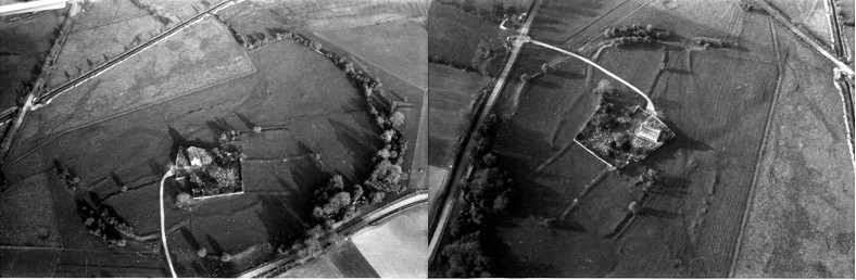
Rahan.
This site contains the church of St Carthage in its original enclosure with the original earthen ramparts around it. The monastery is inside a large D shaped enclosure with the River Clodiagh forming the northern boundary. The enclosure is 500 m x 325 m, covering field boundaries to the south, west and east. The outer bank is made from earth with an external bank/fosse. In 1870 Thomas Stanley described the inner enclosure as having two earthen banks with intervening fosse.
In recent times Dr Paul Gibson has carried out extensive geophysical surveys of the interior which reveals sub-rectangular inner enclosures.
Rahan from early and current OS maps
Killeigh.
The enclosures around Killeigh are probably the largest in the country. Many elements of them have survived, the remainder ploughed out. The full extent of the enclosures is best seen through aerial photography and survives in the south east of the village. Another part can be seen to the south west of the village in a field to the west of a lane that runs past Abbey Farm. Otherwise, elements of the original enclosures are seen as ragged cropmarks from aerial photography.
Artistic view of Killeigh Historic Landscape published on Offaly.ie
Cooleeshill.
Close to Roscrea this enclosure is an impressive cashel, built of stone on the basis that stone was more readily available than earth. This site is dedicated to St. Kieran of Seirkieran.
Cooleeshil from OS maps
Wheery
Another early site with a river as a significant element of the enclosure, similar to Durrow and Seirkieran. Earlier called Kilwheery. Situated on the flood plains of the river Brosna the river provides the southern boundary of a D-shaped enclosure measuring 55m x 35m at maximum. From an account in the Kilkenny Archaeological Journal, during drainage works in 1849 a bell, enclosed in a shrine was found in a pool in the Brosna just beside the site.
Maps from the early OS surveys and modern satellite photo
Kildangan – Tihilly
Tihilly is located between Tullamore and Durrow. Human bones are said to have been found in the site which was levelled during the last century and is no longer visible at ground level. The ecclesiastical enclosure consisted of a large circular area enclosed by an earthen bank which acted as a circular field boundary. The site seems to have contained a graveyard and a holy bush. Folklore stories collected in the 1930s describe the annual Patron Day rituals carried out at Tihilly. The comparison between the 1830s OS map and the modern photo identifies the destruction to the original church site for agricultural purposes.
Maps from the early OS surveys and modern satellite photo
Fancroft.
Early church enclosure within an archaeological rich landscape containing church and graveyard. There is no modern access road but there is a trace of a sunken road to the NE of the site that may have led to the original church site.
This short article is the first in a series designed to look at the growth of Tullamore over the period from 1622 and to take key dates in the development of the town. Suggested dates will include 1622, 1716, 1764, 1785, 1804, 1835, 1900, 1923, 1948, 1966 and 2000. These dates coincide with particular events, or the availability of documentary sources that may allow us to draw some conclusions about the state of Tullamore at varying times over the last four centuries. Rather than take matters in chronological order we are going to look for some key moments in the stages of growth. One such was the completion of the canal to Tullamore in 1798 and its extension to Shannon Harbour in 1804. During that six years Tullamore had served as the depot and terminus for the new waterway to the west and south. The opening to Shannon Harbour and the link to the Shannon may have been seen by some as marking the end of the new canal hotel and harbour in Tullamore with business moving further west and travellers no longer having to stop over in the town. That was not the case. The hotel client base weakened to almost nothing by the 1840s and so did passenger traffic. Commercial traffic was continued on until 1960.
All the books here can be purchased from Offaly History (Bury Quay, Tullamore and online) and at Midland Books, Tullamore. You can also view/ borrow at Offaly Libraries and consult at Offaly History Centre.
Rathrobin and the two Irelands: the photographs of Middleton Biddulph, 1900-1920. Michael Byrne (Offaly History, Tullamore, 2021), 330 pages, 280×240, hardcover, €24.99.
Rathrobin is a book that keeps on giving. Its 250 Biddulph photographs from the 1870s to 1920s, all carefully captioned, depict the two Irelands – unionist and nationalist, Catholic and Protestant, landed and cabbage garden. What is interesting about the pictures of Colonel Biddulph (1849-1926) of Rathrobin near Mountbolus are the nuances. He was of the lesser gentry, was a tenant of the Petty Lansdownes, and was well aware of the Plantations of the 16th and 17th centuries. He appreciated the needs of the farm labourers and was decent to his own tenants, staff and farm workers. His entire estate was not much more than a 1,000 acres. Biddulph’s circle was also the lesser gentry and those who served it such as land agents, bankers and clergy. The Catholic Protestant divide was strong but landed Catholic families did mix in Bidduph’s set, but not merchants or traders (even if very rich). Biddulph had an empathy with his farm workers and their families and sought their advancement. Many local families were photographed, together with the farming activities of his own employees.
Biddulph’s story, and that of his associates and friends, is illustrated by a selection of over 300 pictures in all, of which 250 are from the Biddulph Collection in Offaly Archives, and fifty more to illustrate the introductory essay and provide the all-important context. The essay and the photographs provide a more nuanced understanding of Ireland in the revolutionary period of 1900–23. Biddulph’s wonderful house at Rathrobin that he had so carefully ‘restored’, and all his farm improvements, were lost in the Civil War in 1923. Many other big houses from Ashford, to Ballyfin, Durrow, Brookfield, Screggan Manor and Charleville are also recorded in this volume. Some such as Brockley Park in Laois are now gone thereby making this an important work of record. The photographs by Middleton Biddulph were taken at a crucial moment in Ireland’s history. Their publication now could not come at a better time. Rathrobin is the portrait of one small estate and Killoughy parish in Offaly from the 1650s to the 1920s, but the story is of national interest. T.E. Lawrence spoke of the Arab Revolt, perhaps in Ireland we can talk of the Irish Revolt and not the full circle Revolution. You decide.
Rathrobin was supported by the Decade of Commemorations Unit in the Department of Tourism, Culture, Arts, Gaeltacht, Sport and Media