54 Charles Coote’s observations on Ballycowan barony and the district of Tullamore for his Survey of King’s County published in 1801. No 54 in the Grand Canal Series from Offaly History

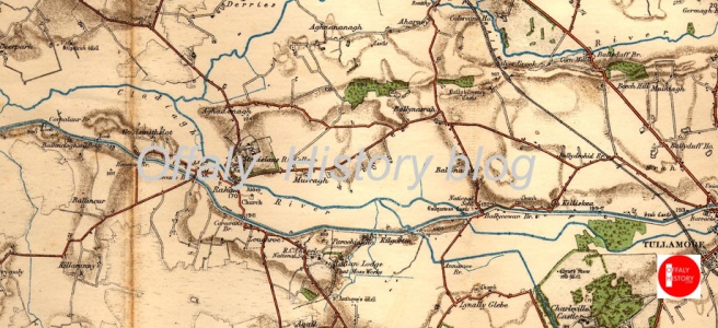
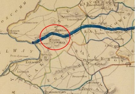
The line of the Grand canal to Philipstown and Tullamore is the only navigation through this county, and is material advantage to the district, through which it passes.  Levels have been taken, and the line laid out for a further extension of this canal to the Shannon, with off branches to Birr and other towns, which is not yet put into execution.

The terminus of the line from Dublin to the Shannon was Tullamore for the years 1798 to 1804 when the link with the Shannon was at last completed. In the 1790s a line to Kilcormac and Birr was considered but on the grounds of expense that along the Brosna was selected.

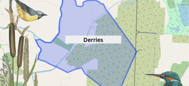
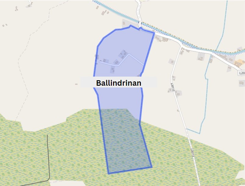
[175] Ballicowan village is the estate of the [176] Earl of Mountrath, and here are the ruins of a castle, which  gives name to the barony.  Turf fuel is in plenty, and had on the cheapest terms. . .

Ballycowan castle c. 1958, it took its present configuration in 1626 and was destroyed by the Cromwellians in the early 1650s with the Cootes succeeding to the estate forfeited by the Herberts.

Tullamore is the market for grain, and indeed the produce of many adjoining baronies is sent thither, there being the fairest sale and a good demand amongst the buyers, occasioned principally on account of the many stores, which were established by the Grand Canal extending here, and which divides this barony for some distance.  This proves the value of inland navigation and gives the farmer in these distant parts the advantage (as we may say), of bringing Dublin market home to his door. 

Continue reading

52-53, Grand Canal Townlands East to West: Ballysheil to Clonony Beg No 52-53 in the Grand Canal Offaly Series. By Philomena Bracken, Offaly History

Ballysheil is in the Electoral Division of Gallen, in Civil Parish of Gallen, in the Barony of Garrycastle, in the County of Offaly. The Irish name for Ballysheil is Baile Uí Shiail meaning the town of O Siail.

Ballysheil townland.ie/ Image Source: https://www.townlands.ie/

In this area we come to two smaller bridges, not far part from each other. Glyn and Judge’s Bridge. You will find the remains of the old Ballysheil house, once a beautiful tall building that stood out for its unique stone work and design. Where it once called home to noble guests, where it saw a number of events over its time, which would have had servants pacing back and forth doing the bidding of lord and lady of the house[1]. You will also find a bawn here this property was owned by the Sheil family, well known for their medical skills. The house and bawn exchanged hands to new owners when the Sheil family were forcibly transplanted to Galway in the mid17th century. If looking around this area along the way, you may also find evidence of a corner tower[2].

Continue reading

50-51, Grand Canal Townlands East to West: Derries to Glyn No 50-51 in the Grand Canal Offaly Series. By Philomena Bracken, Offaly History

With the construction of the Grand Canal from the late 1750s, brought with it the expansion of Trade. goods could be carried from East to West along the line, this helped boost the development of the local economy from the late 18th century. The Offaly section of the canal runs approximately 42 miles and is home to a number of species and wild plants, due to the cross over through wet bog land during the development of the canal way[1].

 The first townland we come to along this way is Derries. It is situated in the Electoral Division of Ferbane, in the Civil Parish of Wheery or Killagally, in the Barony of Garrycastle, in the County of Offaly. The Irish name for Derries is Na Doirí meaning The Oak Woods.

Derries townland map. Image Source: Townlands.ie / Illustrations Nature on Irish Canals by Paul Francis

Wheery or Killagally is a large civil parish and it extends about 7 miles from Pollagh Village.

Continue reading

48-49, Grand Canal Townlands East to West: Pollagh to Turraun No 48-49 in the Grand Canal Offaly Series. By Philomena Bracken, Offaly History

Pollagh also spelt as Pullough, is located in a small village in County Offaly, it is in the Civil Parish of Lemanaghan. A small parish, it extends from Ballycumber to Ferbane. Pollagh village can be found on the north side of the canal. The Parish lies in the territory of Dealbhna Eathra of the MacCoghlans – an ancient people. It has a rich heritage in its archaeology including the important monastic site, churches, and ringforts and the famous castles.

One of The townlands that we come along as we work our way down the line is Pollagh, the name in Irish is Pollach, meaning Place full of Holes.

TownlandAreaPop in 1841Pop in 1851No. of Houses in 1841No. of Houses in 1851Pop in 1871Pop in 1911No. of Houses in 1871No. of Houses in 1911
Pollagh907 26716843332822234250
An interesting profile in the fall and rise of the population due one assumes to the successful brick industry.
Continue reading

46-47, Grand Canal Townlands East to West: Ballindrinan to Cornalaur No 46-47 in the Grand Canal Offaly Series. By Philomena Bracken, Offaly History

Rahan, Civil Parish is situated in the ancient O’Molloy territory of Fear Ceall meaning Men of the Woods or Men of the Churches. It is bounded on its north west side by the Brosna River. Its bedrock is Limestone and it has deposits of brick and clay along the Grand Canal.

The townlands from Ballydrohid, Tullamore to Cornalaur
Ballindrinan Townland/ Image Source Townlands.ie

Its best know archaeological site is the Rahan Monastic Centre which was an area of great importance in the early Christian Period.

Townland: Ballindrinan is in the Electoral Division of Rahan, in Civil Parish of Rahan, in the Barony of Ballycowan, in the County of Offaly.

The Irish name for Ballindrinan is Baile an Draighneáin meaning land of the blackthorns.

Continue reading

45 The landscape of east Offaly: Croghan Hill and Clonsast. Frank Mitchell describes the landscape of east Offaly taking in Croghan Hill and Clonsast bog. No. 45  in the Grand Canal Offaly series

Frank Mitchell (1912–97) was a distinguished but unassuming academic, environmental historian, archaeologist and geologist. While he had many academic writings his best known book was The Irish Landscape (1976) about which he was typically modest. In 1990 Mitchell published ‘a semi-autobiography’ The way that I followed. The title was a play on Robert Lloyd Praeger’s, The way that I went (Dublin, 1937). Praeger in his peregrinations was less kind to Laois and Offaly than Mitchell with Praeger’s observation that neither county need detain us long (p. 235) and ‘there is not much of special interest’ (p. 237). Westmeath he found to be more hospitable than Offaly having less than half of the amount of bog in Offaly and more pasture. We may look at the Praeger account in another blog

Continue reading

43-44 Grand Canal Townlands East to West: Kilgortin/Killina/ Loughroe. No 43-44 in the Grand Canal Offaly Series by Offaly History

Kilgortin is in the Electoral Division of Rahan, in Civil Parish of Rahan, this parish is situated in the ancient O’Molloy territory of Fear Ceall meaning the mem of the woods or men of the churches. If you look closely along the line in this area you will see deposits of brick clays along the Grand Canal between Ballycowan and Rahan, this was the source of an energetic brick industry in the past.  In this part of Rahan you will find the site of Rahan Monastic Centre, this is the most famous archaeological site in this location. It was a very important aspect of Early Christian period.

Continue reading

42 The Way that I followed, Frank Mitchell (1990). In this extract Mitchell describes the landscape of west Offaly taking in the Shannon and the eskers. No. 42  in the Grand Canal Offaly series

Frank Mitchell (1912–97) was a distinguished but unassuming academic, environmental historian, archaeologist and geologist. While he had many academic writings his best known book was The Irish Landscape (1976) about which he was typically modest. In 1990 Mitchell published ‘a semi-autobiography’ The way that I followed. The title was a play on Robert Lloyd Praeger’s, The way that I went (Dublin, 1937). A delightful exercise in ‘topographical autobiography’. Praeger in his peregrinations was less kind to Laois and Offaly than Mitchell with Praeger’s observation that ‘neither county need detain us long’ (p. 235) and ‘there is not much of special interest’ (p. 237). Westmeath he found to be more hospitable than Offaly having less than half of the amount of bog in Offaly and more pasture. We may look at the Praeger account in another blog. Suffice to say that bogs were not flavour of the month with the visitors from the 1800s to the 1930s and who wrote up accounts of their tours. Mitchell did not follow that century old prescription.

Someone who Mitchell would have known (at TCD) and admired was T.W. Freeman. The latter’s Ireland a general and regional geography (1950, third edition, 1963) provided a useful account of the boglands east of the Shannon and the eskers of the Central Lowland with a brief disquisition on the market towns ‘that differ so strangely in their material prosperity’. Freeman was fascinated by the unexpected and haphazard nature of economic life in some of the towns – he seems to have had in mind Tullamore and Clara.

In any case let us go back to look at what Mitchell wrote of the terrain east of the Shannon as part of this Grand Canal series.

Continue reading

40-41 Grand Canal Townlands East to West: Carton West/ Kilbride/Ballycowan No 40-41 in the Grand Canal Offaly Series. Offaly History

Coming into Carton West, a small townland east of Tullamore that can be found in the Kilbride civil parish, this parish following the division of the original parish, is distinct from a second civil parish of the same name (Clara). The landscape in this area is mainly woodland, with a bedrock of dark Limestone, as in in the Ballyduff Quarries, this was used in the 19th century Tullamore buildings.

Ballycowan castle in view, about 1958.

This parish lies in the ancient O’Molloy territory of Fir Ceall or Men of the Churches or Men of the Woods. Here you will find many archaeological sites, which some have been destroyed or taken back by nature.

Carton West is in the Electoral Division of Silverbrook, in Civil Parish of Kilbride, in the Barony of Ballycowan, in the County of Offaly The Irish name for Carton West is An Cartrún Thiar meaning the West Carton (land Measure). This is an old measure of land.

Continue reading

39 Charles Coote on the rural landscape in 1800 as the canal was completed as far as Tullamore. No 39 in the Grand Canal Offaly series

The Grand Canal reached Daingean in 1797. The changing landscape along the route of the new canal from Edenderry at its survey in 1800. Sir Charles Coote describes Philipstown /Daingean in No. 33 in the Grand Canal Offaly Series

The Grand Canal reached Daingean (Philipstown 1557-1920) in 1797 having been dug by upwards of 3,000 men from the access to the county at Cloncanon, Edenderry in about 1793. The next stage was making the line from Edenderry to Rhode, Toberdaly, Killeen bridge and into Daingean where the Molesworth bridge was built in 1796. After that it was on to Ballycommon, the 26th lock (Boland’s. ‘the Round House’) and the drop down all the time to Tullamore which was reached in 1798. The fall over the eight locks, from no 21 to no 28 at Clara bridge, Tullamore was about 73 ft. It was five years before the connection from the main line of canal at Cloncanon and Drumcooly was completed to Edenderry in 1802.

Coote in the survey published in 1801, dedicated to none other than General Vallancey who had surveyed the proposed line of the Grand Canal as far back as 1770 (see an earlier blog), was able to describe the scene close to the line of new canal of which so much was expected.

Continue reading