Rahan, Civil Parish is situated in the ancient O’Molloy territory of Fear Ceall meaning Men of the Woods or Men of the Churches. It is bounded on its north west side by the Brosna River. Its bedrock is Limestone and it has deposits of brick and clay along the Grand Canal.
Its best know archaeological site is the Rahan Monastic Centre which was an area of great importance in the early Christian Period.
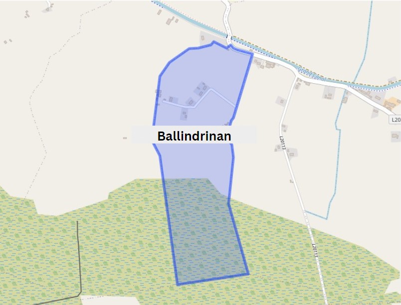
Townland: Ballindrinan is in the Electoral Division of Rahan, in Civil Parish of Rahan, in the Barony of Ballycowan, in the County of Offaly.
The Irish name for Ballindrinan is Baile an Draighneáin meaning land of the blackthorns.

In 1911, Ballindrinan had one of the lowest private dwelling housing records in the census, during this period the household returns and ancillary, shows us that there were just 4 buildings all Private Dwelling, with two inhabited, of 2nd class. The families that occupied these buildings were between the ages of 8- 63. followed:

| Townland | Area | Pop in 1841 | Pop in 1851 | No. of Houses in 1841 | No. of Houses in 1851 | Po in 1871 | Pop in 1911 | No. of Houses in 1871 | No. of Houses in 1911 |
| Ballindrinan | 132 | 41 | 29 | 6 | 6 | 26 | 28 | 7 | 8 |
The history of the name is from Logainm.ie. Sources include the Down Survey maps of the 1650s and the bog maps of the early 1800s. Reference is also made to the estate map owned by Barry Fox. He and his family lived at Annaghmore and we have an article on the family in the Offaly Heritage journal series.

Townland: Rahan Demesne in the Electoral Division of Rahan, in Civil Parish of Rahan, in the Barony of Ballycowan, in the County of Offaly. The Irish name for Rahan Demesne is Raithean meaning Ferny Land.
| Townland | Area | Pop in 1841 | Pop in 1851 | No. of Houses in 1841 | No. of Houses in 1851 | Pop in 1871 | Pop in 1911 | No. of Houses in 1871 | No. of Houses in 1911 |
| Rahan Demesne | 391 | 74 | 119 | 13 | 25 | 91 | 64 | 20 | 16 |

In 1911, Rahan Demesne had one of the highest private dwelling housing records in the census, during this period the household returns and ancillary, shows us that there were 16 buildings all of Private Dwelling, with 14 inhabited, of 1st 2nd and 3rd class. The families that occupied these buildings were between the ages of 1- 80. With occupations from Farmers, Carpenters and shop keepers followed:


In Rahan Demesne you will find St Carthach’s Abbey. Also known as St Carthage. It was founded in the late 6th Century by St Carthach.
There are remains of three churches that can be found in this local area, as well as a graveyard, all these historical features are surrounded by enclosures. Each one holds centuries of memories, looking at one of these ancient churches has been incorporated into the new church erected in the early 18th century.


Romanesque door way features are identified by their carved detail into the stone, intricate designs and layered effect going from front to back, bringing you into the entrance way. The above arch above the modern door at Carthage’s gives us a look into the work of stone craft back during this period. Today we can still see that these details and craftsmanship has stood the test of time and the elements. Along with its entrance way, it has some well-preserved stone work around windows[1].
The history of the name brings us back to the Annals of Ulster of the seventh century

Along the line we could to Newtown, this townland is in the Electoral Division of Rahan, in Civil Parish of Rahan, in the Barony of Ballycowan, in the County of Offaly.
The Irish name for Newtown is an Baile Nua.


In 1911, Newtown had a large number of private dwellings recorded in the census, during this period the household returns and ancillary, shows us that there were 16 buildings all of Private Dwelling, with all inhabited, of 2nd class status. The families that occupied these buildings were between the ages of 1- 73. With occupations from Farmers and Servants, below shows some of the families that occupied these dwellings at this time.


Next we come to Goldsmithslot in the Electoral Division of Rahan, in Civil Parish of Rahan, in the Barony of Ballycowan, in the County of Offaly
The Irish name for Goldsmiths lot is Lota Goldsmith
| Townland | Area | Pop in 1841 | Pop in 1851 | No. of Houses in 1841 | No. of Houses in 1851 | Pop in 1871 | Pop in 1911 | No. of Houses in 1871 | No. of Houses in 1911 |
| Goldsmiths lot | 148 | 94 | 85 | 17 | 15 | 57 | 12 | 10 | 16 |

In 1911, Goldsmiths lot had a small number of private dwellings recorded in the census, during this period the household returns and ancillary, shows us that there were 8 buildings all of Private Dwelling, with 5 inhabited, of 2nd class status. The families that occupied these buildings were between the ages of 3- 79. With occupations all in the same field of Farmers, below shows some of the families that occupied these dwellings at this time.

In smaller townlands in the Rahan area, no features can be found, only ruins that once were cottages and barns that were more likely abandoned during the times of hardships, such as the famine, that affected a lot of the smaller townlands during this period.
It was seen all along the line during the famine of desperate and scared people attacking and pillaging the trade boats as they went along the line. Patrols were set up and most boats were advised to set up at night along a patrol station.

Goldsmith appears to have been a Cromwellian soldier. The shape of the townland is highly unusual and has the profile of a planters’ strip shared out in the Cromwellian ‘Settlement’.

Townland: Cappaloughan in the Electoral Division of Rahan, in Civil Parish of Rahan, in the Barony of Ballycowan, in the County of Offaly.
The Irish name for Cappaloughan is Ceapaigh an Locháin meaning Tillage Plot of the Little Lough.
| Townland | Area | Pop in 1841 | Pop in 1851 | No. of Houses in 1841 | No. of Houses in 1851 | Pop in 1871 | Pop in 1911 | No. of Houses in 1871 | No. of Houses in 1911 |
| Cappaloughan | 159 3 38 | 31 | 22 | 5 | 5 | 40 | 26 | 7 | 6 |

In 1911, Cappaloughan 6 private dwellings recorded in the census, during this period the household returns and ancillary, shows us that there were all inhabited and in the 2nd class category. The families that occupied these buildings were between the ages of 6- 71. With occupations all in the same field of Farming , below shows some of the families that occupied these dwellings at this time.


Townland: Ballincur, in the Electoral Division of Rahan, in Civil Parish of Rahan, in the Barony of Ballycowan, in the County of Offaly.
The Irish name for Ballincur is Baile an Churraigh meaning T/Land of the moor.
As we walk along we come to a few bridges, all very close to each other. First we have Corcoran’s Bridge, then we arrive at Becan’s Bridge, which is then followed shortly by Henesy’s Bridge.

| Townland | Area | Pop in 1841 | Pop in 1851 | No. of Houses in 1841 | No. of Houses in 1851 | Pop in 1871 | Pop in 1911 | No. of Houses in 1871 | No. of Houses in 1911 |
| Ballincur | 331 | 119 | 79 | 16 | 15 | 42 | 18 | 11 | 5 |

Ballincur had a record of 5 private dwellings all inhabited of 2nd and 3rd class category. The families that occupied these buildings were between the ages of 1- 80. With occupations of farmers and Agricultural Labourer. below shows some of the residences that occupied these dwellings at this time.

After We make our way from Henesy’s Bridge We come to Ballincloghan Bridge, Ballincloghan Townland is in the Electoral Division of Rahan, in Civil Parish of Rahan, in the Barony of Ballycowan, in the County of Offaly.
The Irish name for Ballincloghan is Baile an Tulcháin meaning T/Land of the Stoney Fort.

Coming along from the Ballincloughin Bridge lies west pf the 30th Lock. Here you will find a Lock-Keeper’s cottage which is still maintained to a high standard. Below we can see the Lock keeper’s cottage and the Bridge associated with Lock 30th.
Lock Keepers played a huge roll in the maintaining of the locks and surrounded areas during the highpoint of the Grand Canal and until the late 20th Century. Some of the jobs that lock keepers had were to see boats through the lock, especially with inexperienced boatmen, as these amateur sailors could accidently cause damage to the lock or its walls. If this were to happen, or a crack came in the sides, it would have to be repaired quickly as it would cause a delay in the filling up of the locks for boats to pass[3].

| Townland | Area | Pop in 1841 | Pop in 1851 | No. of Houses in 1841 | No. of Houses in 1851 | Pop in 1871 | Pop in 1911 | No. of Houses in 1871 | No. of Houses in 1911 |
| Ballincloghan | 208 | 63 | 54 | 8 | 8 | 53 | 50 | 9 | 7 |

Ballincloghan had a record of 7 private dwellings all inhabited of all 2nd class homes. The families that occupied these buildings were between the ages of 1- 80. With occupations of boatmen, Boat drivers, Lockkeepers and Agricultural Labourers, below shows some of the residences that occupied these dwellings at this time.


To keep the running of the line along the grand canal operating efficiently employees worked together to ensure the upkeep and smooth sailing of each boat along the way. Boat drivers along with a number of boatmen depending on the size of their boat, would play a major role in maintaining the safe travel of cargo from start to its final destination and where seen as key figures during this time.
Lock keepers had the important role of upkeep of the general area their where assigned, along with tending to the locks and lock gates to keep a look out for cracks, leaks or any damage cause by natural waring down of the limestone and by the moving thought of the boats. The also guided boats through the gates.
Just a short walk from here we come to Cornalour townland, is in the Electoral Division of Rahan, in Civil Parish of Rahan, in the Barony of Ballycowan, in the County of Offaly.
The Irish name for Cornalaur is Corr an Urláir meaning Edge of the Level Area.
| Townland | Area | Pop in 1841 | Pop in 1851 | No. of Houses in 1841 | No. of Houses in 1851 | Pop in 1871 | Pop in 1911 | No. of Houses in 1871 | No. of Houses in 1911 |
| Cornalaur | 553 1 25 | 121 | 69 | 20 | 14 | 80 | 51 | 17 | 12 |

Cornalaur had a record of 12 private dwellings 10 inhabited of all 2nd class category. The families that occupied these buildings were between the ages of 1- 80. With occupations of Farmers, Lock Keepers, and Farm Servant. below shows some of the residences that occupied these dwellings at this time.

Cornalour Bridge, west of this is 31st Lock. This bridge is an arch bridge, limestone with rubble thoughout It is a Hump-backed bridge, these style of bridges were connected more with locks along the way. It was constructed by the Grand Canal Company in the early 1800s.

It also has a lock keeper’s house still in great condition to the side. Which can be seen in the photos below[4].


As we make out way pass the 31st Lock we come into Pollagh Village, which we look at in more detail on the next series of did you know? Facts along the Grand Canal including some of the historical features still surviving.

[1] Rahan Looks Back. Sister Oliver Wrafter. Pub Rahan 1998. Pp9-29.
[2] See “The Grand Canal of Ireland” Ruth Delany. The Lilliput Press 1995, Chapter 5, pp 161-165.
[3] “ The Grand Canal” Ruth Delany, The Lilliput Press, 1995, pp 183-187
[4] Bridges of Offaly County: An Industrial Heritage Review. Fred Hamond. Pub: November, 2005, pp 304-305.
