With the construction of the Grand Canal from the late 1750s, brought with it the expansion of Trade. goods could be carried from East to West along the line, this helped boost the development of the local economy from the late 18th century. The Offaly section of the canal runs approximately 42 miles and is home to a number of species and wild plants, due to the cross over through wet bog land during the development of the canal way[1].
The first townland we come to along this way is Derries. It is situated in the Electoral Division of Ferbane, in the Civil Parish of Wheery or Killagally, in the Barony of Garrycastle, in the County of Offaly. The Irish name for Derries is Na Doirí meaning The Oak Woods.

Wheery or Killagally is a large civil parish and it extends about 7 miles from Pollagh Village.
| Townland | Area | Pop in 1841 | Pop in 1851 | No. of Houses in 1841 | No. of Houses in 1851 | Pop in 1871 | Pop in 1911 | No. of Houses in 1871 | No. of Houses in 1911 |
| Derries | 720 2 23 | 51 | 41 | 8 | 8 | 51 | 19 | 7 | 6 |

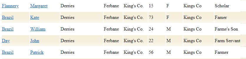
In 1911 Derries had 6 houses on record in the area, during this period the household returns and ancillary, shows us that there were 6 buildings all of Private Dwelling, with all inhabited, with classes of houses between 2nd and 3rd . Here are some of the families that occupied these buildings during this time:
the landscape along this area of line, provides a unique eco system. Even in built-up areas the canal line running through the centre, from East to West, creates a peaceful and quiet place to spend some time away from the rush of everyday life. On closer look you will discover a variety of nature and wildlife. Originally constructed for transporting of people and cargo goods up and down the line to one port to another, never realising the usefulness that was right under their noses, Fish. Not until the early 20th century were canals seen as fishing venues.
Now Ireland alone has become a focal point for coarse fishing and the Grand Canal along the east to west way has become a part of their own when it comes to fishing venues. It has becoming an amenity for both the angler community and visitors near and wide.

| Townland | Area | Pop in 1841 | Pop in 1851 | No. of Houses in 1841 | No. of Houses in 1851 | Pop in 1871 | Pop in 1911 | No. of Houses in 1871 | No. of Houses in 1911 |
| Derrycarney | 364 | 93 | 58 | 15 | 11 | 27 | 14 | 4 | 4 |
Derrycarney, is in the Civil Parish of Gallen. It is in the territory of Delbhna Eartha and was in the territory of Mac Coghlan. Clohan Village lies in the centre of the Parish, and is a great spot off along the way to grab a coffee and do some window shopping. The parish has an extensive area of Bogland.

This Parish has significant archaeological remains, including the Ecclesiastical sites, these sites include Monastic and sites of medieval churches as well as some graveyards[2]. You will find a number of these sites located around the Townlands that are under this Parish, It is the highest concentration of ecclesiastical sites.

In 1911 Derrycarney had four houses on record in the area, during this period the household returns and ancillary, shows us that there were six buildings all of Private Dwelling, with all inhabited, with 2nd class houses. four families occupied these buildings with family members between 3-7 during this time it was recorded the youngest age at this time was 10 and the oldest was 68.

In the Barony of Garrycastle, in the County of Offaly .The Irish name for Derrycarney is Doire Uí Chatharnaigh Meaning O’Kearney’s Wood. As we head southwest on the canal we reach Derry Bridge.

This section of canal opened in 1804, and was constructed by the Grand Canal Company in the early 18th century. There seems to be no heritage significance connection with this bridge and no trace on it could be found, with most bridges during the construction of the Grand Canal only have features to go by, split into two different categories freestanding and not associated with locks, such as the Derry Bridge. And Lock Bridges, there’s can be found alongside a lock or close by, these were built to a higher standard during the time.
Just past Derry Bridge along the towpath, you will find the remains of Kilcolgan Castle, If you want to skip off the beating path for a while, this is a lovely gem to spot and explore. This castle ruin is located just north of the Derry Bridge, about 1.2 miles away.
As we make our way just to the boarder of Derrycarney we come to one of the most well-known of the Aqueducts along the line, MacCartney Aqueduct. This Aqueduct, was constructed in the early 19th century and was named after a member of the Grand Canal Company, called John MacCartney. This is one of few Aqueducts alone the line that survived as many were disused and left. And is also recorded as one of three major Aqueducts that are still in use today[3].

Next we see in the distance Armstrong Bridge.

From the Aqueduct to Armstrong Bridge also known as the Gallen Bridge , there is a long length of walk way, some spots are uninhabited and flood during the rainy season, it is home to a few trees, Hawthorn and brambles in spots. Is also known as Gallen Bridge.

Falsk is in the Electoral Division of Gallen, in Civil Parish of Gallen, in the Barony of Garrycastle, in the County of Offaly The Irish name for Falsk is Failsce meaning is unknown.
| Townland | Area | Pop in 1841 | Pop in 1851 | No. of Houses in 1841 | No. of Houses in 1851 | Pop in 1871 | Pop in 1911 | No. of Houses in 1871 | No. of Houses in 1911 |
| Falsk | 1,007 | 11 | 56 | 15 | 11 | 140 | 108 | 28 | 20 |

In 1911 Falsk had 20 houses on record in the area, during this period the household returns and ancillary, shows us that there were 20 buildings all of Private Dwelling, with all inhabited, with 2nd and 3rd class houses. Families that occupied these buildings had members between 2-14 living together during this time it was recorded the youngest age at this time was 1 and the oldest was 84.

As we walk along this line we come across many birds, which can be spotted just feet from each other, Canals can be considered as linear ponds, very slow moving rivers, were the water supply is driving from numerous streams, springs and rivers. Most of which flow from the canals highest point, this ensures a constant flow of water. As canals are slow moving, this results in a range of wildlife living in small proximity to each other[4].

Swans are one of the largest bird in Ireland, if provoked, they can quickly take up a defensive stance, with loud hissing, wing flapping and can result in a full attack if defending their young or if you come into close contact with a nest. Always be careful when walking along the canals, as swan use the stalks of common reeds to construct their nest along the side of the banks.
Herons, are common resident along the banks of the canals during the summer months standing quietly among the reeds until it spots its prey from fish, frogs and young water hens, they prefer quiet rural stretches of the canal, with trees nearby that they can roost in. These birds are easily identified by their white and grey feathers, long legs and neck, with a sharp beak.


Gallen is in the Electoral Division of Gallen, in Civil Parish of Gallen, in the Barony of Garrycastle, in the County of Offaly.

The Irish name for Gallen is Gailinne meaning Rocky Land. During the construction of the Grand Canal passages traveling on the canal from Dublin to Birr had to disembark at Gallen, from there a coach would collect them and bring them the rest of their journey to Birr. The Jessop service went out of business when Charles Bianconi began a new coaching service that provided the same service to Gallen to Birr route open car with a standard rate of one penny per mile[5]. This venture did not last long, after a few years the coach service was abandoned as the route was not viable financially.

With The coming of the canal, it proved a great boom especially the brick making industry in Gallen. During the 19th century boat loads of bricks from Gallen and surrounding areas were sent to Dublin and other parts of the country that the canal could reach. By this time the Canal Company had seen a huge jump in the boats it owned with between twenty to thirty barges going up and down the line. Along with the transport of brick, other goods were transported too, including, flour, corn, turf, potatoes and even animals were transported along the lines during this period.

Two boats that could be seen going along the line was the “The Rose of Gallen and “The Maid of Gallen”. Later, in the mid 20th century, the Grand Canal Company was taken over by C.I.E. and ten years later all trade boats were withdrawn from the canal[6]


In 1911 Gallen had a large number on record in the area, during this period the household returns and ancillary, shows us that there were 23 buildings all of Private Dwelling, with all inhabited, with 2nd and 3rd class houses. Below shows us some of the inhabits that lived here during 1911.

As we come to the end of Gallen we step into Noggusduff townland, in the Barony of Garrycastle, in the County of Offaly. The Irish name for Noggusduff is Cnogús Dubh meaning Black Herb.
| Townland | Area | Pop in 1841 | Pop in 1851 | No. of Houses in 1841 | No. of Houses in 1851 | Pop in 1871 | Pop in 1911 | No. of Houses in 1871 | No. of Houses in 1911 |
| Noggusduff | 313 | 276 | 254 | 55 | 46 | 102 | 52 | 16 | 12 |

In 1911 Noggusduff had 12 buildings on record in the area, during this period the household returns and ancillary, shows us that were all of Private Dwelling, with all inhabited, with 2nd and 3rd class houses. Below shows us some of the inhabits that lived here during 1911.

Noggus Bridge can be seen up ahead, shortly we arrive at Glyn Bridge. As knowns as the 32nd Lock. The lock house associated with this lock is not inhabited anymore. From here you are treated to a lovely grassy route, this area is one of the spot where wildlife thrives and continues to multiply each year.
Unlike Rivers, which change during their journey out to sea, Canals do not, they are slow moving. And therefore the full range of wildlife along the canal can be seen in a small area[7].

Both sides of a canal is consisdent of long grass around the bank, suitable for insects and fish and somethings you find the odd turtle or two. The reeds and wild flowers, make great camoflas for small animals such as water hens, Wrens, Field Mouse and Shrew.


Coming outside to the inner side of the town path we find trees, Hawthorn been the most common tree to find in the hedgerow., along with Bushes Some may continue berries or two that make perfect, finds for hedgehogs, Grey Squirrels and birds.

Noggusboy is in the Electoral Division of Gallen, in Civil Parish of Gallen, in the Barony of Garrycastle, in the County of Offaly.
The Irish name for Noggusboy is Cnogús Buí meaning Yellow Herb. In this townland a Mesolithic stone axe was found in Noggusbog bog.

| Townland | Area | Pop in 1841 | Pop in 1851 | No. of Houses in 1841 | No. of Houses in 1851 | Pop in 1871 | Pop in 1911 | No. of Houses in 1871 | No. of Houses in 1911 |
| Noggusboy | 687 | 150 | 148 | 30 | 25 | 60 | 48 | 10 | 8 |

During this time in the area 12 houses were on record, the household returns shows us that of the 12, 8 houses were occupied, These houses where of 2nd and 3rd class, with the available family members between 3 to 11. The age range was of 1 to 81.


Glyn is in the Electoral Division of Gallen, in Civil Parish of Gallen, in the Barony of Garrycastle, in the County of Offaly.
The Irish name for Glyn is An Gleann meaning the Valley.
| Townland | Area | Pop in 1841 | Pop in 1851 | No. of Houses in 1841 | No. of Houses in 1851 | Pop in 1871 | Pop in 1911 | No. of Houses in 1871 | No. of Houses in 1911 |
| Glyn | 136 | 38 | 17 | 8 | 3 | 13 | 9 | 2 | 3 |

During this time Glyn had a low housing record, 3 in 1911 with all occupied with 2 families and 1 single person. These houses where of 2nd class, with the family members between 1 to 5 in each household. The age range was between 14- 69.


As you have seen from above we have only scratched the surface of what you will find along the canals, there is still a wild range of wildlife to discover, when nature watching along the line don’t forget to watch out for the canal bank. As it’s easy to misplace a step when you get distracted by the beautiful nature around you.
In addition, don’t forget to bring a camera or notepad along with you to document your findings and enjoy the wildlife in its natural environment. Remember don’t try bring the wildlife back home with you, by picking plants, or capturing wildlife, you are disturbing the natural echo system of the canal. Most importantly don’t forget to have fun[8].

[1] See “Nature on Irish Canals” Brid Johnson and Marie Dromey, The stationery Office, Pp1-2.
[2] Offaly Through Time & It’s Townlands Thomas Lee.Pub Ottait Publishing. 2018.256-258. Pp97-163.
[3] Bridges of couty offaly a heritage review.Fred Hamond. Pub Offaly County Council. P23-25.
[4] Westland discovered. Thompson price limited. Pub: The Forest Wildlife Service. Pp 41-45.
[5] On Gallen Green the story of a west Offaly Townland. Brendan Ryan. Pub 2020. White Grass Publications. Pp 38-46.
[6] On Gallen Green the story of a west Offaly Townland. Brendan Ryan. Pub 2020. White Grass Publications. Pp 38-46
[7] Wildlife on Irish Canals. The Office of Public Works.
[8] See “Nature on Irish Canals” Brid Johnson and Marie Dromey, The stationery Office, Pp30-44.
