With the construction of the Grand Canal from the late 1750s, brought with it the expansion of Trade. goods could be carried from East to West along the line, this helped boost the development of the local economy from the late 18th century. The Offaly section of the canal runs approximately 42 miles and is home to a number of species and wild plants, due to the cross over through wet bog land during the development of the canal way[1].
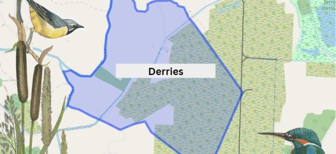
The first townland we come to along this way is Derries. It is situated in the Electoral Division of Ferbane, in the Civil Parish of Wheery or Killagally, in the Barony of Garrycastle, in the County of Offaly. The Irish name for Derries is Na Doirí meaning The Oak Woods.
Derries townland map. Image Source: Townlands.ie / Illustrations Nature on Irish Canals by Paul Francis
Wheery or Killagally is a large civil parish and it extends about 7 miles from Pollagh Village.
Part two of this presentation looks at the Charleville and Macartney aqueducts west of Tullamore and the Silver River aqueduct halfway between Ballycommon and Kilbeggan.
THE CHARLEVILLE AQUEDUCT
The Clodiagh River rises in Knockachoora Mountain in Sliabh Bloom and flows swiftly through Clonaslee and on under Gorteen, Clonad and Mucklagh bridges into Charleville Demesne before passing under the Charleville Aqueduct, just before its confluence with the Tullamore River at Kilgortin in Rahan. Less than half a mile upstream on the canal stands the Huband Aqueduct overlooked by the imposing Ballycowan Castle.
The Charleville Aqueduct is called after Charles William Bury who had become Viscount Charleville in December 1800 and it was as such, he was recorded in the lists of attendees of the Court of Directors of the Grand Canal Company during the years the canal was being constructed from Tullamore to Shannon Harbour, 1801-04.
Image 1.excerpt from the minutes
An excerpt from the minutes of a meeting of the canal company held 24th February 1801 where Lord Charleville’s request for the use of one of the company’s boats for the purpose of conveying Lady Charleville to town was accommodated. The memo further states that his wife was in a precarious state of health, most likely an allusion to her being in the advanced stages of pregnancy as her son Charles William Bury was born nine weeks later, on 29th April 1801. (Courtesy of National Archives of Ireland, Dublin)
Image 2. Charles William Bury, 2nd earl
Charles William Bury, 2nd Earl of Charleville, born late April 1801, seated in red cloak before a curtain, portrait by Henry Pierce Bone, 1835.
C. J. Woods’s entry for the first earl of Charleville, (1764-1835), in Dictionary of Irish Biography, R. I. A., (2009), gives a concise résumé of his adult life:
Bury was MP for Kilmallock in 1789–90 and 1791–7, becoming Baron Tullamore on 26 November 1797, Viscount Charleville on 29 December 1800, and 1st earl of Charleville (of the second creation) on 16 February 1806. He was an Irish representative peer from 1801 until his death. With Johnston he designed and built a Gothic castle on his demesne, Charleville Forest, 3 km south-west of Tullamore. Begun by November 1800, it was completed in 1808, to which a terrace, lawns, artificial lake, grotto, and 1,500 acres of woodland were added. Elected a fellow of the Royal Society in 1803 and a fellow of the Society of Arts in 1814, Charleville had ‘wide intellectual interests which never came to fruition’. The earl of Charleville died 31 October 1835 in his lodgings at Dover and was buried at Charleville.
Fred Hammond’s great survey of the bridges in Offaly (2005) gives the following description of the building:
Triple-span masonry bridge carries Grand Canal over Clodiagh River. Abutments, piers and cutwaters are of dressed limestone blocks, regularly laid. The cutwaters are of triangular profile and rise to arch spring level at both ends of the piers. The arches are of segmental profile and each spans 3.07m; their voussoirs are of finely dressed stone. The soffits are very slightly dipped towards their centres to accommodate the bed of the canal. Dressed string course over arch crowns. Parapets are of random rubble, coped with dressed masonry blocks. The parapets are spaced at 10.08m and terminate in out-projecting dressed stone piers. The east end of the south parapet has been rebuilt. The canal narrows to 4.50m, with tow paths either side. The sides are stone lined at this point and there are timber stop slots at the east end of the aqueduct.
Hammond considered the edifice worthy of regional heritage importance.
THE MACARTNEY AQUEDUCT
Image 3.Detail of William Ashford’s painting
Detail of William Ashford’s painting of the crowded scenes at the opening of the Ringsend Docks, Dublin, 23 April 1796, showing Lord Camden, the Lord Lieutenant of Ireland, conferring a knighthood on Mr. John Macartney with the Westmoreland, Buckingham and Camden Locks in the background. Macartney can be seen in a genuflected position on the right-hand quay wall beneath a billowing British naval flag. (Courtesy of the National Gallery of Ireland)
This is the western-most aqueduct in Offaly straddling the townlands of Falsk and Derrycarney, south of Ferbane. The structure is named after Sir John Macartney, one of the more influential directors of the Grand Canal Company. As alluded to above he was knighted by the Lord Lieutenant at the opening of the Grand Canal Docks in 1796, “in consequence of his energetic exertions in the promotion of the inland navigation of Ireland.” Like Huband’s Aqueduct at Ballycowan, it has two commemorative plaques dating it to 1803.
Image 4. Commemorative plaque dated 1803
Commemorative plaque dated 1803 on the south parapet wall of the Macartney Aqueduct.
Fred Hammond’s appraisal of the building says it all:
This is the largest aqueduct on the Grand Canal in Co. Offaly and second only to the Leinster Aqueduct (Co. Kildare) in size on this canal. It is of high-quality construction and has been sympathetically refurbished. It is of historical interest due to attested date and link with Grand Canal Co. Also, a substantial landscape feature hereabouts. Of national heritage significance, meriting inclusion in Record of Protected Structures.
Image 5. A delightful drawing by Israel Rhodes
A delightful drawing by Israel Rhodes, dated to March 1802, showing details of the steam-powered pump that was used during the construction of the Macartney Aqueduct over the Silver River. This is from the minute books of the Grand Canal Company where such visual representations are very rare. The depiction is signed by Rhodes as engineer and by Arthur Chichester Macartney, then an influential director of the canal company. (Courtesy of National Archives of Ireland, Dublin)
The aqueduct crosses the fast-flowing Silver River after it has meandered over twenty-miles from the slopes of Wolftrap Mountain high up in Sliabh Bloom The river’s course takes it through Cadamstown, Ballyboy, Kilcormac and Lumcloon before joining with the Brosna half a mile downstream of the aqueduct.
Image 6. Map by John Longfield c.1810
Map by John Longfield c.1810 showing the Grand Canal turning sharply to the north-west just downstream of the Macartney Aqueduct and thus avoiding the Gallen, Cloghan and Lumcloon complex of bogs before meandering (almost) from Gallen to Belmont, always in close proximity to the River Brosna. The Silver River is depicted as the Frankford River in deference to the old name for Kilcormac, the last town it passes through before its confluence with the Brosna. (Courtesy of The National Library of Ireland)
SILVER RIVER AQUEDUCT ON THE KILBEGGAN BRANCH
To avoid confusion with the other Silver River crossed by the Macartney Aqueduct, this aqueduct straddles the Silver River which separates the counties of Offaly and Westmeath between the townlands of Bracklin Little and Lowertown. The river rises upstream of New Mill Bridge, in Rahugh, in Westmeath. In Offaly it flows via Derrygolan, Acantha, Gormagh, Ballyduff, Aharney, Coleraine, Coolnahely and Aghananagh before joining the Clodiagh at Aghadonagh, in Rahan. The 1838 six-inch map shows five mills on this relatively short river. The earliest of these mills is probably that at Ballynasrah or Tinnycross as it is shown on John Gwin’s map of the Barony of Ballycowan which was drawn c.1625, almost four hundred years ago.
Image 7. Detail of John Gwin’s map showing Silver River
Detail of John Gwin’s map of the barony of Ballycowan which shows the Silver River flowing from Ballynasrah in the bottom left-hand corner to its confluence the Clodiagh at Aghadonagh on the right- hand side, passing Ballyduff, Aharney and Tullymorerahan. The mill is indicated by a mill-wheel symbol. The map is part of a set of twenty-eight important maps of various parts of Offaly drawn four hundred years ago in the Mathew De Renzy papers in the National Archives in London.
KILBEGGAN BRANCH
As early as 1806 the Grand Canal Company’s engineer John Killaly had prepared a detailed map for a proposed branch from Ballycommon on the main canal to Kilbeggan. This line was closely adhered to when work finally begun twenty-four years later in 1830. An application for funding was made in 1825 and despite strenuous objections from the Royal Canal Company a loan was approved in 1828. In March 1829 Killaly had completed the plans and specifications for the line. A month later William Dargan’s proposal to build the line for £12,850 was accepted.
Image 8 William Dargan
William Dargan, (1799-1867)
From the outset work was slow due to continuous wrangling between the contactor and the company. Dargan had taken his own levels, but the canal company insisted he use those of Killaly. Even when progress was made recurring problems with staunching the huge embankments at Bracklin Little and Lowertown delayed construction. Allied to this was the major distraction of Dargan’s involvement with the building of Ireland’s first railway line.
Image 9. Bracklin Little and Lowertown townlands on the1912
Bracklin Little and Lowertown townlands on the1912 Ordnance Survey six-inch map, showing the meandering Silver River and the dense hachuring between Lowertown and Murphy’s bridges. This represents the steep slopes of the embankments which carry the aqueduct high above the surrounding landscape. Note the overflow at south end of the aqueduct. This was to prevent the level of the canal rising to a height where it would overflow the banks and lead to a major breach. Just like at the Blundell Aqueduct there were twenty-six miles of canal without a lock which would have poured out at this point if a burst occurred, leading to much destruction and a long-term closure of the navigation.
Dargan’s chief biographer Fergus Mulligan describes this episode in Dargan’s life in the Royal Irish Academy’s Dictionary of Irish Biography:
Ireland’s first railway line, the Dublin & Kingstown, opened in 1834 and Dargan was fortunate to win the contract to build it against six competitors. Working under another Telford pupil, Charles Vignoles (qv), as engineer, Dargan began work near Salthill in April 1833, and although he was six months late finishing the line (which opened on 17 December 1834) the penalty clauses in his detailed contract were not enforced. The successful completion of this line gave Dargan a springboard to winning a substantial share of Irish railway construction contracts on offer in the 1840s and 1850s.
Again, we are greatly indebted to Fred Hammond’s monumental survey of all 407 bridges in Offaly in 2005 for a detailed description of this aqueduct:
A tall arched masonry bridge carries the disused Kilbeggan Branch of the Grand Canal over the Silver River at the county boundary. The abutments are of dressed limestone blocks, regularly laid and with finely dressed quoins. The arch is of semi-circular profile, with finely dressed radial voussoirs and dressed stone soffit blocks; it spans 3.59m. The arch is embellished with finely dressed string courses around the tops of the quoins and across the crown. Over the top of the upper string course are four regular courses of dressed stone blocks. They are surmounted by a slightly inset random rubble parapet. The sloping wing walls are detailed as the abutments and are coped with stone flags.
The pioneering travel book on the Irish canals was Green and Silver (London, 1949) by L.T.C. Rolt. Tom Rolt made his voyage of discovery by motor cruiser in 1946 along the course of the Grand Canal, the Royal Canal and the Shannon navigation from Boyne to Limerick. The Delanys writing in 1966, considered Rolt’s book to be the most comprehensive dealing with the inland waterways of Ireland. [1] In this extract Banagher gets a severe press very unlike the optimism of the 1890-1914 period and again in the 1960s. Banagher also got a severe jolt post 2008. Things are now improving with sunlit uplands breaking through.
Moving off to Shannon Harbour Rolt got sight of the many arched bridges at Shannon Bridge and passed beneath the swinging span. See last week’s blog by Donal Boland covering the same trip in 2023 as far as Tullamore.
Shannon Harbour with the police barracks and the collector’s/agent’s house.
“Just below, was the Grand Canal depot with a canal boat lying alongside the quay. Opposite, and commanding the bridge was a gloomy fortress backed by a defensive wall of formidable proportions which extended westward like a grey comb along the crest of yet another of the green esker ridges. It was a symbol of the more peaceful times that have now come to the Shannon that, according to the signs displayed, part of the fortress had now become a village shop and bar.”[2]
A singlehanded trip from the River Shannon to the town of Tullamore along the western section of the Grand Canal was conducted by the writer over seven days in August, 2023. The trip was conducted aboard the heritage vessel Bomb Scow a converted thirty-three foot Royal Navy seaplane tender. Our thanks to Donal Boland for this comprehensive overview of the Brosna Line, Shannon Harbour to Tullamore which is better presented as one extensive with its helpful picture coverage. This comprises articles 6 to 10 in the series on Grand Canal Offaly.
Content
Overview
Entrance from the River Shannon
First Lock Number 36
Lock 36 to 35
Lock 35 to 34 Shannon harbour
Lock 34 to 33 Clonony Barracks
Lock 33 Belmont…
Belmont to Tullamore
Memories
Appendix 1: Hull and Spoke Concept
Appendix 2: The Napoleonic Aspect
1. Overview
A singlehanded trip from the River Shannon to the town of Tullamore along the western section of the Grand Canal was conducted by the writer over seven days in August, 2023. The trip was conducted aboard the heritage vessel Bomb Scow a converted thirty-three foot Royal Navy seaplane tender.
The trip, was a fact-finding event to record the on-water experience as part of an initiative to highlight the possibility of attracting more visitors to this section of the canal. Described here as The Grand Extension, previous research had revealed its construction was later than the eastern section of the canal and forming part of the British Militaries Napoleonic defensive network.
The route commenced in the west on the callow fringed landscape of the River Shannon, travelling through boglands on a raised section of the canal and terminating to the east in an Esker dominated upland landscape, encountering the villages of Shannon Harbour, Belmont, Ferbane, Pollagh, Rahan and the town of Tullamore.
The Stllwater Navigation extending for a distance of twenty two miles and rising some ninty feet is comprised historically of the waterway, ten locks, twenty bridges, eighteen aquaducts, four feeders and four spillways. Presently the waterway is managed by four lock keepers or waterway patrollers with overlapping areas of responsibility, who operate the lock systems and control the sections water levels.
The Grand Extension, Town and Villages The heritage vessel Bomb Scow moored on The Grand Extension
2. Entrance from the River Shannon
The Stillwater navigation of The Grand Extension is accessed from the River Shannon by way of the Brosna River and its confluence with the Shannon. This entrance is characterised by magnificent over-hanging foliage to the north and earthen banks associated with the canal’s construction to the south. An isolated, derelict bridge-keeper’s cottage that stands on Bullock Island is passed as you enter the River Brosna waterway.
The confluence of the River Brosna waterway with the River Shannon
The River Brosna waterway
The confluence of the River Brosna Waterway and The Grand Extension
3. Lock Number 36
Lock 36 is the final, lowest lock on the Grand Canal system and the first lock you meet when arriving from the River Shannon. A long, floating jetty stands on the southern bank immediately below the lock, providing access to land by way of a large sloping ramp. The lock constructed of cut-stone is entered via wooden balanced, hanging gates that incorporate water control sluices, operated by the lock keeper utilising a rack and pinion mechanism mounted on the gates topside. The gates are opened and closed by way of the long balance beam that extends from each gate.
An engraved stone plaque mounted on the north wall of the lock, details the construction and features of the extension.
The entrance to Lock 36 and its large waiting jetty
The empty cut-stone lock chamber and wooden gates
The full lock chamber and upper-gates
The upper lock gates opened and the ever-attendant lock keeper
4. Lock 36 to 35
This short section of the canal provides an initial experience and understanding of the Stillwater navigation. It is many times narrower than the River Shannon with a defined navigation path bordered by moored vessels to the north and a rich reed-based ecosystem to the south.
Entering the first section of The Grand Extension
The short canal section extending from Lock 36 to Lock 35
Lock 35
5. Lock 35 to 34
The second, Lock 35 on the system, provides access from the first level up to the second level which is comprised of Shannon Harbour, Griffith and Clonony bridges and a section of canal extending to the thirty fourth lock that contains numerous moored vessels for most of its length The waterway beyond the moored vessels starts to provide an understanding of the true characteristics of this Stillwater navigation.
A feature of this canal is the construction of bridges and locks immediately adjacent to one another, this allowed for the transfer of horses (which were originally employed to pull barges along the navigation) from one towpath to the other.
Entering Shannon Harbour
Shannon Harbour
The canal extending to Clonony Bridge and Lock 34
Clonony Bridge and Lock 34
6. Lock 34 to 33
The section of canal east of Lock 34 is best described as the military section as along its northern bank lies the remains of Clonony Military Barracks – most likely the military destination of the canal and the reason it was constructed swiftly. The military grounds are defined to the west by a wooden fence and metal gate and to the east by a long roadside timber fence. The towpath within the military grounds is substantially wider encompassing a lay-by or mooring area. Immediately east of the military grounds lies L’Estrange Bridge and Quay which was utilised by the L’Estrange family for commercial purposes possibly associated with the barracks.
The canal beyond L’Estrange Bridge and Quay displays its mature natural character as a tranquil linear still-waterway navigation mostly devoid of habitation and humanity broken only by the arrival of Belmont Mill.
The Eastern and Western boundaries of the Military Lands
The lay-by and broader towpath within the Military Grounds
L’Estrange Bridge / Quay and Belmont Store
The magnificent natural features of The Grand Extension
7. Lock 33
Lock 33 or Belmont Lock is the only double lock on the Grand Extension. A double lock is constructed when a high lift is required at a location. The standard lift for locks on the canal is circa eight feet while the lift a Belmont Lock is some fifteen feet. Transiting this lock is a delightful experience hard to describe and best experienced.
Belmont Mill and Lock
Lock 33 at Belmont
Filling the lower level
Filling and emerging from the upper level 8.Belmont to Tullamore
The canal extending east from Belmont Lock to Tullamore is best described as isolated continuous delightful for some and a horror for others. The mind may transition into a relaxed static state imbibing the natural landscape and the activities of inhabiting creatures or one may be bored to insanity. The architecture of the locks, bridges and associated buildings coupled with the relatively unchanged landscape propels one back in time to the period of the canal’s construction in the early eighteen hundreds. This relaxation is interspersed by interludes of surprise and delight when a bridge is encountered and frantic activity when locking from one level to another. The villages of Gallen/Ferbane, Pollagh and Rahan when encountered are a connection with present times providing basic mooring facilities. The town of Tullamore provides an opportunity for the replenishment of supplies and the possibility of fresh water. The facilities available to the canal traveller are sparse and presently reflect the industrial era of canal usage.
A simple water tap
The continuous Stillwater Navigation
A canal bridge endowed with generations of growth
Bell’s Bridge and Lock 32
Gallen Village, bridge and rest area
Gallen Village bankside mooring area
Pollagh Village and Canal-Side facilities
Lock 31
Lock 30 and the canal manager’s house.
The canal-side facilities at Rahan Village and the Thatch pub – a former Williams branch shop
Ballycowan Castle of 1626 and beside it the Huband aqueduct dated to 1803. Huband was a barrister and a director of the Canal Company from 1777 for most of the years to 1835.
Srah Castle, Bridge and and the railway bridge
Sragh Bridge and Lock 28
Entering Tullamore at the Clara Road Lock 29
The spur from the canal main line to Tullamore Harbour
The canal side facilities in Tullamore Town
9. Memories
Memories of this trip are especially positive
The waterway was weed free with a good water level
The courtesy and efficiency of the water patrollers was first class
The lock landings were in a good condition
The lock operating systems all worked well
The lock surrounds were neat and well maintained
The lock keeper’s cottages were a joy to behold
Canal-side moorings and services were adequate and of their time
The site on which Hollow House can be found on is one that has changed and adapted throughout its time starting in the 17th century. The first sign of life in the area is the bawn wall for the residence that was said to be “built by de Renzi” it can be assumed that there was a castle on the site because of an ordnance survey stating ‘Castle in ruins’. It is certain that they were living incredibly comfortably for the time because of their previous home in Clonony castle for eight years from 1612 to1620 before leaving and eventually buying the land where Hollow House stands today. The bawn and circular towers found in the area were originally built with defence in mind, as time passed their use became more domestic. The towers were repurposed as pigeon towers.
Remaining part of the bawn wall from the outside
The gardens at Hollow House have been described as early-eighteenth century by Maurice Craig and William Garner but the 1838 ordnance survey of Tinnycross seems to confirm no such gardens are depicted. However, the same survey also left out a large lake near Birr castle so it is still possible that the features were simply left out for some reason or another. This same issue presents itself with putting a date on the creation of the decorative pond in the garden as it first appears in a 1910 ordnance survey of Tinnycross, but since the 1838 survey may be unreliable, it is uncertain when the pond was actually built. The farmyard beside the house shows signs of being built in the mid-late 1800s, the largest building has a corner slab with the year 1863 seen on the wall. The pond in the garden includes two stone structures built in three tiers of oddly shaped limestone rocks, the gaps in these stones were more than likely used by water fowl as a shelter. These structures were decorative pieces more than anything, it is unfortunate to note that one of these structures was destroyed by a falling tree in recent years, the stones from the structure remain in the place where it once stood.
Long shot of the gardens, house, pond and turrets at Hollow House,
Sir Matthew De Renzy (1577-1634) was born in Cologne, Germany. It must be noted that the surname de Renzy has been spelt de Renzi or de Renci and these spellings were used interchangeably on different documents. He became a cloth merchant in Antwerp, one of many merchants who held control over the trade in the city, this fell apart due to a decline in trade in the area which was caused by a conflict between the Dutch United Provinces and the ruling Spanish Hapsburgs which led him to move to London in 1604, he found himself in financial difficulty in early 1606 and when he was unable to recover enough money from merchants who owed him, he was then declared bankrupt. With his creditors were pursuing him so he fled rapidly to Ireland via Scotland arriving in Dublin in August, without a penny to his name.
His main ambition upon arrival was to obtain land and he understood that to achieve this successfully he would need friends in high places. He made many good contacts in Dublin and further afield including Sir Arthur Chichester, then Lord Deputy of Ireland. As a polyglot he was fluent in Latin, Italian, English, German, French and Spanish and set about learning Irish he learned both spoken and colloquial Irish from Conchubhar and Tadhg Mac Daire MacBruaideadh he also learned classical Irish in Sligo from Tadhg Ó hUiginn so that he could read Irish manuscripts and write in the language this new skill aided him in communicating with the Gaelic Lords at the time and gaining the trust and more importantly, their land. He acquired 100 acres in Clonony where he lived in the castle that remains standing to this day. His 100 acres expanded to over 1000 acres in the following years.
Hollow House c. late 1970s. Courtesy Offaly History
In around 1620 he sold his land in Clonony and became a government administrator in Dublin, he was knighted in 1627. Not much is known about his marriage but he was first married in 1608 to Mary Adams and his second marriage was to Anne Maypowder. His interest in the Irish language was purely from the perspective of a planter attempting to gain land in a functioning Gaelic Lordship that still remained in Offaly at the time. Despite his affinity in their language the local farmers and families often disrespected his claim to the land he lived on often ploughing on his land and de Renzy had to fight hard to keep his claim on any land in the area both legally and literally, this conflict may have been the reason for the defensive style found at Hollow House. He also had a son Matthew de Renzy, his heir. In 1630 he purchased land near Tinnycross Co. Offaly, in the name of his eldest son. De Renzy died in 1634, his son Matthew Jr. commissioned a memorial for his father in St. Mary’s Church Athlone where it can be seen today.
Matthew Jr. was listed as the owner of the land in Tinnycross in the Down Survey of 1654-6, during his ownership of the land he let it to Francis De Renzy who lived there with his wife Elizabeth Keane. Francis died in 1665 and is commemorated in Durrow church with a carved grave slab. This stone was moved outside to the north face in about 2004. His wife remarried and eventually died in 1686. The land came into the hands of the Cox family of Ferns through another Matthew De Renzy in 1704. Sir William Cox was cited as the owner in Griffith’s Valuation of 1854. He leased it to Edward Kelly who has been noted to live in Tinnycross in a list of landholders in King’s Co. 1824 and Griffith’s valuation 1854. It is also noted in Griffith’s valuation that Edward Kelly was also leasing small amounts of land to several people in the area, Michael Seery, William Freyn, Christopher and Elizabeth Hackett and James Lynham. It can be assumed that the land remained to be leased to different families for residence and farming for the next 50 or so years until eventually coming into the hands of the Walsh family where they would continue to live in the area for most of the 20th century and beyond.
Map of 1838 showing Hollow House with the inscription “Castle in ruins”
The beginning of the 20th century sees Hollow House being inhabited by two young men Patrick Walsh, 18 listed as the Head of the Family and his younger brother Andrew, 17. Looking at the House and Building Return from the 1901 census the landlord listed for their dwelling was Michael Walsh who appears to be their father from his own census record with many children and of perfect age to have had both of the brothers. Another link between them is that Michael is listed as a farmer under his own occupation while the young men put themselves down as farmer’s sons. The evidence suggests that the brothers had started to farm on their own just north of where their father lived and worked with the rest of the rather large family having eight other children at home and a servant to help either on the farm or around the house. By 1911 we can see that Andrew has started a family with his wife, Elizabeth and two young children Michael and Patrick.
Archaeology.ie provides the following:
Townland: BALLYNASRAH OR TINNYCROSS
Description: An early Georgian farmhouse is situated on the site of castle of which nothing remains. The four round corner towers along with bawn wall and round arched gateway with triangular pediment and spiral finials all belong to the late 18th or early 19th-century and were built after the castle was destroyed probably by the occupiers of the now ruinous Georgian farmhouse. An early Georgian farmhouse is situated on the site of a castle of which only the bawn survives. The four circular angle towers along with part of the bawn wall (OF009-023001-) appear to date from the seventeenth century. The round arched gateway with triangular pediment and spiral finials appear to belong to the late eighteenth or early nineteenth-century and were built after the castle was destroyed probably by the occupants of the ruinous farmhouse. The back wall of this cottage is part of the earlier bawn wall of 17th century date. Probable plantation castle of 17th century date with large rectangular bawn wall with four corner flanking towers. The wall and angle towers are defended with gun loops that provided flanking fire along the outer face of all four walls of the bawn.
The above description is derived from the published ‘Archaeological Inventory of County Offaly’ (Dublin: Stationery Office, 1997). In certain instances the entries have been revised and updated in the light of recent research.
Offaly History members and friends at Hollow House, late 1970s. The picture includes Fr Conor McGreevy, Baron von Ow, Ger Coughlan, Cecil Lumley, Danny Robbins, Joan McGill, John Devereaux, Frank Meehan, Tom Galvin, Owen Wyer, Mrs J. Doyle. Younger members Terese and Noel Scully, Brendan Doyle.
Scheduled for inclusion in the next revision of the RMP: Yes
Description: An early Georgian farmhouse is situated on the site of a castle of which only the bawn survives. The four circular angle towers along with part of the bawn wall appear to date from the seventeenth century. The round arched gateway with triangular pediment and spiral finials appear to belong to the late eighteenth or early nineteenth-century and were built after the castle was destroyed probably by the occupants of the ruinous farmhouse. The back wall of this cottage is part of the earlier bawn wall of 17th century date. Probable plantation castle (OF009-023—-) of 17th century date with large rectangular bawn wall with four corner flanking towers. The wall and angle towers are defended with gun loops that provided flanking fire along the outer face of all four walls of the bawn.
When Christians arrived in Ireland and started to write about the country they found an island of Gaelic kingdoms, perhaps up to 150, that was dynastic and the political organisation was based on the tuath. The tuath was the bedrock of the Gaelic political system and is described as a small kingdom. Most of what we know now has been gleaned from the Irish Law Tracts, commonly known as the Brehon Laws. Other written sources include the Hero and Saga Tales.
In 1120 Turlough O’Connor, high-king of Ireland, built a ‘principal’ bridge on the River Shannon at a place called Áth Cróich. Recent study has proven that this is an earlier name for Banagher.
SIR MATHEW DE RENZY (1577-1635)
Sir Mathew De Renzy writing in December 1620 about West Offaly with particular reference to roads and passageways made two clear statements regarding a major crossing point on the River Shannon at Banagher and how there was practical and convenient access to the West and Galway from that location.
1. ‘At the Benghar there ought a towne or a good fort to be made, to keep that passage of the Shannon, for that in no other place can come any horsemen near the river to take passage out of Connaught but only here, by reason of the impediments of the bogs and woods; from this passage it is but 30 or 34 miles to Galway all hard and fair ground.
2. At Banagher ‘…to be no more than about 30 miles (from the Shannon at Ahcro or Benghar to) to Galway over the Shannon, all hard and faire ground
Both these references leave no doubt that there was a major crossing point at Banagher in the 1620s. More importantly the second quote equates Banagher with a place called Ahcro (Áth Cróich). This information was crucial to the recent acceptance by the Locus placenames project (Locus) that the two places are synonymous. Consequently, in future editions of their definitive dictionary of Irish placenames, Banagher and Áth Cróich will be recorded as one and the same place. The implication of this decision is that it requires a major revision of Banagher’s early history.
Growing up on Clontarf Road, Tullamore, on the banks of the Grand Canal in the 1950s and 1960s I spent many childhood hours playing beside the canal. This was where my father’s family had lived for generations in East View Terrace before he and several of his siblings had acquired houses in Frank Gibney’s new state-of-the-art housing on Clontarf Road. In early teenage years I took to walking the canal line and ventured to Kilgortin Mill and Rahan, where my mother’s people, my grandfather and uncles and a multiplicity of cousins, lived. Not surprisingly the canal got under my skin if not indeed into my bloodstream.
Hiking west from Tullamore the ‘canal line’ took us to exotic locations: The Metal Railway Bridge and slow-moving trains, the inaccessible Srah Castle, Molloy’s Bridge for in-season snowdrops and horse chestnuts and the hugely impressive six-chimneyed Ballycowan Castle, overlooking the imperious and impervious Huband Aqueduct. Rambling east towards Cappancur we soon explored in detail the small aqueduct which seemingly miraculously ushered the Barony River under the canal and were further allured by the rotundity of Boland’s lockhouse and a lock manned by a team of sisters. Graduating to the bicycle we set out along the towpath for far-flung towns and villages: Ballycommon and the Wood-of-O, the Kilbeggan Branch, historic Daingean and the outré but warm and welcoming church at Pollagh.
Grand canal from the 27th lock at Cox’s Bridge, Tullamore about 1910Continue reading →
To conclude our Heritage Week series of talks online we want to tell you the illustrated talk New light on Irish county map-making in the early 19th century – tracings from William Larkin’s map of King’s County/ Offaly, c. 1808 has now been uploaded. You get a 30-minute introduction from the leading expert on the early maps of Offaly. This is followed by minute comparisons of the Larkin tracings for west Offaly with the published Larkin atlas of 1809. Dr Arnold Horner has prepared an in-depth lecture on map-making in King’s County in the early nineteenth century where he analyses the significance of the new map tracings attributed to William Larkin which were donated to Offaly Archives last year, and conserved by Liz D’arcy through Heritage Council funding. He particularly looks at features in the landscape around Birr, Banagher, and Ferbane.
With thanks to Offaly Archives last Tueday’s lecture (16 Aug. 2022) by Dr Arnold Horner is now online as are the maps which are recently conserved.
Tullamore is a well-preserved town and is the county town of Offaly since an act of parliament in 1832 displaced Philipstown (Daingean) which had been the county town since the shiring of Offaly as part of the new colonial government policies in 1557. The new county to be known as King’s County was then comprised of the baronies reflecting the Gaelic lordships of the O’Connors and that of the O Dempseys. The king in question was none other than Philip II of Spain married at that time to the tragic Queen Mary of England (1553–58) hence the new forts of Philipstown and Maryborough (Portlaoise). The county was extended about 1570 to include the territory of the O Molloys (now to be the baronies of Ballycowan, Ballyboy and Eglish) and also that of the Foxes in Kilcoursey and the MacCoghlans in what would be called Garrycastle. In 1605 the territory of the O Carrolls (to form the baronies of Ballybritt and Clonlisk) was added, as also was the parish of Clonmacnoise (1638) at the behest of Terence Coghlan of Kilcolgan. Those looking for an exciting seventeenth-century history for Tullamore will be disappointed as the surviving evidence of town growth in that troubled century is thin. This week we continue to series to mark the 400th anniversary of Tullamore as a town.