
Tullamore is the county town of Co Offaly, it lies on the Grand Canal. It is a large and thriving place that has seen great development over the years. In this article, have a look back with a picturesque timeline through from 1798 when the canal reached Tullamore. We will return to Tullamore stories of the canal when the east west tour is completed.
Kilbride Parish: Seven Miles from East to West. The Parish lies in the ancient O’Molloy territory of Fir Ceall, or Men of the Church. It contains main archaeological sites some of which have sadly been destroyed or taken back by nature.
Tullamore is in the Electoral Division of Tullamore Urban, in Civil Parish of Kilbride, in the Barony of Ballycowan, in the County of Offaly. The Irish name for Tullamore is Tulach Mhór meaning Great Hill. The rising ground in Tullamore leads to the hill at High Street – Cormac Street.

01.Grand Canal, Kings Co. Offaly map Image Source: Offaly History

04. Tullamore , Image Source: Townlands.ie
The Grand Canal reached Tullamore in 1798, and was a major boost to the town and the smaller townlands that surrounded it. Philipstown did not fare so well from the canal and progress was slow. But for Tullamore the construction of the Grand Canal could not of come at a more perfect time, as during this time Tullamore was recovering from a major fire which took place in 1785, it destroyed over 100 homes. A lot of factors were at play in the growth of the town over the years 1785 to 1840.
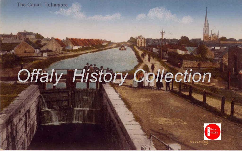
As we work our way along we come to 25th Lock and Digby Bridge also known as Cappincur Bridge just outside of Tullamore from here see if you can spot the spiral of the Church in Tullamore erected in 1906 and so St Catharine’s of 1815.
When you reach pass this lock point you come to a nice walk path, it’s a lovely area that has a combination of wildlife flowers and you can even spot some cranes and water hens along the way. The path way is made up of Grass and gravel.

Coming along you will come to the 26th Lock, one of the more well-known locks along this line. As it is situated at Boland’s Lock House.

Due to the “Balloon Fire” at the time, it was noted in an inspector’s report that Tullamore was in need of more accommodation in the town. It was agreed upon that a harbour should be constructed and a hotel should be built to house the passengers that would arrive via boats. In 1801 the boarder awarded the project to a stoneworker contractor known for his works on the locks and bridges of the canal. Michael Hayes also been involved in the building of the 26th Lock house, now known as Boland’s.
This Lock house which was one of Hayes earlier buildings was seen as unnecessary at the time by the Board and while building the first Canal hotel was ordered to pay a fine of £42.11s.7d, this was taken out of his pay. Today would be at least €5,000. We will have a special blog on the 26th lockhouse later in the series.

One thing that makes this lock stand out from the rest its castle like front entrance. Walking down we come to an open pathway, of grass wild flowers and open fields.
If doing this walk on a late evening or night, don’t forget to look up above and watch out for the bats. This type of bat you find close to the water is known as the “water bat”. They fly low down and mostly of the surface of water, trying to catch the insects with its feet[2].
As we start to make our way inwards 1 and a half kilometres along the line, you come to Whitehall aBridge. Also Known as Bury Bridge during its construction in about 1800.
Just at this bridge we come to a corner that leads us underneath the free standing bridge and out to a long strength of water, were boats dock during the summer months. Keeping to this line we come to old canal warehouses [3}.


The metal bridge at Convent View-Park Avenue, Tullamore provided access to a new park in the mid-1930s. The park was soon built on but the bridge survived until the current sturdy structure of 2013.
Parish: Seven Miles from East to West. The Parish lies in the ancient O’Molloy territory of Fir Ceall, or Men of the Church. It contains main archaeological sites many have sadly been destroyed or taken back by nature.
Townland: Puttaghan: is in the Electoral Division of Tullamore Urban, in Civil Parish of Kilbride, in the Barony of Ballycowan, in the County of Offaly. The Irish name for Puttaghan is An Puiteachán.

| Townland | Area | Pop. in 1841 | Pop. in 1851 | No. of Houses in 1841 | No. of Houses in 1851 | Pop. in 1871 | Pop. in 1911 | No. of Houses in 1871 | No. of Houses in 1911 |
| Puttaghan | 486 | 145 | 142 | 30 | 27 | 54 | No data | 11 | No Data |
In 1871 Puttaghan had 11 buildings recorded of houses in the area, during this period the household returns and ancillary, shows us that there was 11 buildings all of Private Dwelling, with 3 inhabited, with classes of houses between 1st 3rd and 2nd. Age ranging from 28-71.Here are some of the families that occupied these buildings during this time:
| Class of House | Surname | Religion | Occupation in House | Family members |
| 3rd | Malone | RC | Farmer | 3 |
| 2nd | Smyth/Batson | RC | Farmer | 2 |
| 1st | Smyth | RC | Farmer | 3 |


Making our way from Kilbeggan Road Bridge, we come along the way, till we come to the Dew Warehouse, now known as “Old Warehouse”. Located just on the Grand Canal, this once beautiful building use to be the Original home of Tullamore Drew. The Building dates back to the late 18th century and was part of the William Group, it was used for the blending and bottling of Tullamore Dew Whiskey. The Grand Canal line brought great businesses to this area, with the help of the canal barges to transport large supplies to Dublin to be exported to different outlets throughout Ireland and international[4].

Walking along the way you come to the 27TH Lock. Just beside Cox’s Bridge Tullamore.

13/14 This is one of the most peaceful walk ways along the line, it takes 1-2 hours to walk the line, but there’s plenty of spot along the way to rest and take in the views, especially on a hot summers day. Walking along you come to the 28th Lock, just pass this is the Tullamore Bypass Bridge. As you walk along you come to the Railway Bridge over the Grand Canal, during the 1916 rising, this bridge was planned to be blown up in April 1916. Lucky this didn’t go ahead and it is still standing today[5].

15. Railway Bridge of 1858-9. Image source: 1916 raising in Tullamore
Townland: Srah
Srah is in the Electoral Division of Tullamore Urban, in Civil Parish of Kilbride, in the Barony of Ballycowan, in the County of Offaly. The Irish name for Srah is An tSraith
| Townland | Area | Pop in 1841 | Pop in 1851 | No. of Houses in 1841 | No. of Houses in 1851 | Pop. in 1871 | Pop. in 1911 | No. of Houses in 1871 | No. of Houses in 1911 |
| Srah | 453 3 12 | 203 | 169 | 38 | 30 | 85 | No data | 27 | No Data |

In 1901 Srah had 15 buildings in the area, during this period the household returns and ancillary, shows us that there was 15 buildings all of Private Dwelling, with all inhabited, with classes of houses between 1st, 3rd and 2nd . Age ranging from 1-80. Here are some of the families that occupied these buildings during this time:

Coming along the way we come to Srah Castle, this castle was built in the late 16th Century by John Briscoe, It is a well preserved with many features surrounding it.
Today the castle is closed off due to health and safety. But can be still seen standing tall, with the adjoining house walls still visible. The castle was original named Shrahikerne Castle Signifying Kearney of the Shragh. John Briscoe had married a lovely young lady whose family name was Kearney, who came from the Townland of Sragh near Tullamore[6]. The datestone for the castle of 1588 is now at Mount Briscoe having been removed from the castle by a Briscoe antiquarian in the early nineteenth century.


As well as Castle ruins along the Srah line, the area is where you will find two Enclosures, these are 35 metres in diameter and enclosed by a deep fosse.

You can find evidence off Srah Castle, on old 1840 O.S maps, a circle of stones was marked[7]. Coming along the towpath from Srah Castle, we come into Ballydrohid we can see a range of plants and vegetation along the line that acts as food source for many of the wildlife that has made along the banks their home. Just in the distance you will see Srah Bridge.
Townland: Ballydrohid belongs to the electoral division Tullamore Rural, the civil parish Kilbride, the barony Ballycowan, and the county of Offaly.
The Irish name for Ballydrohid is Béal an Droichid. Meaning Entrance to the Bridge. Ballybroid is also were you will find some Semicircular Enclosures. There are enclosed by a deep fosse, now only visible from the south side.

| Townland | Area | Pop. in 1841 | Pop. in 1851 | No. of Houses in 1841 | No. of Houses in 1851 | Pop. in 1871 | Pop. in 1911 | No. of Houses in 1871 | No. of Houses in 1911 |
| Ballydrohid | 310 1 27 | 80 | 58 | 15 | 11 | 54 | 14 | 9 | 7 |

In 1911 Ballydrohid had 7 houses in the area, during this period the household returns and ancillary, shows us that there was 7 buildings all of Private Dwelling, with 14 inhabited, with classes of houses between 3rd and 2nd . The population from 1841 to 1911 had decreased by 66 people. Here are some of the families that occupied these buildings during this time:


Townland Killiskea:
Killiskea is in the Electoral Division of Tullamore Rural, in Civil Parish of Kilbride, in the Barony of Ballycowan, in the County of Offaly.
The Irish name for Killiskea is Coill Uisce meaning Wood of Water.
A Holy Bush known as the Mass Bush from Penal Times can be found in this area. Stories have been passed now for years on the local feature, it is said to be the first hawthorn bush to leaf every year.

| Townland | Area | Pop. in 1841 | Pop. in 1851 | No. of Houses in 1841 | No. of Houses in 1851 | Pop. in 1871 | Pop. in 1911 | No. of Houses in 1871 | No. of Houses in 1911 |
| Killiskea | 223 | 100 | 77 | 20 | 16 |

In 1911 Killiskea had 12 buildings on record all of living dwellings during this period it shows us that 10 were occupied, Age raging from 1-88. Here are some of the families that occupied these buildings during this time:

“There is a Mass bush in Killiskea. It is in a ditch on the side of the road. The Mass bush is round and wide and flat on the top.
The Mass bush gets its leaves in March and it has its blossoms before the other bushes get their leaves. Long ago the Priests used to say Mass under this bush out in the field”[9].

As we come to the end of the line we make our way along into Kilbride and Ballycowan, join us next time as we look at the Ballycowan castle in detail and the history surrounding the local area.
[1] See”TownPath Tours. A Guide to Cycling Ireland’s Waterways. John Dunne. Pub: The Collins Press. Pp87-88”
[2] See “Nature on Irish Canals” Brid Johnson and Marie Dromey, The stationery Office, Pp30.
[3] Hidden Harbour. The Grand Canal at Tullamore and its lost industrial architecture. Eimear Gallagher. Pub 2021. Pp6-7.
[4] Tullamore County Offaly Birthplace of Tullamore Dew Irish whiskey and Irish Mist Liqueur. Pub: Tullamore Dew Heritage Centre 2000. Pp17-22.
[5] Tullamore in 1916, the making of the Tullamore incident. Michael Byrne. Pub: Esker Press Tullamore 2016. Pp 225-228
[6] Offaly, Through Time & Its Townlands. Thomas Lee. Pub. Ottait Publishing. 179
[7] See “Towpath tours a guide to cycling Ireland’s Waterways” John Dunne. Collins Press. 2005. P98-99
[8] [8] Offaly, Through Time & Its Townlands. Thomas Lee. Pub. Ottait Publishing. 179
[9] https://www.duchas.ie/en/cbes/5044599/5024843Ballykilmurry · The Schools’ Collection | dúchas.ie (duchas.ie)
